 |
|
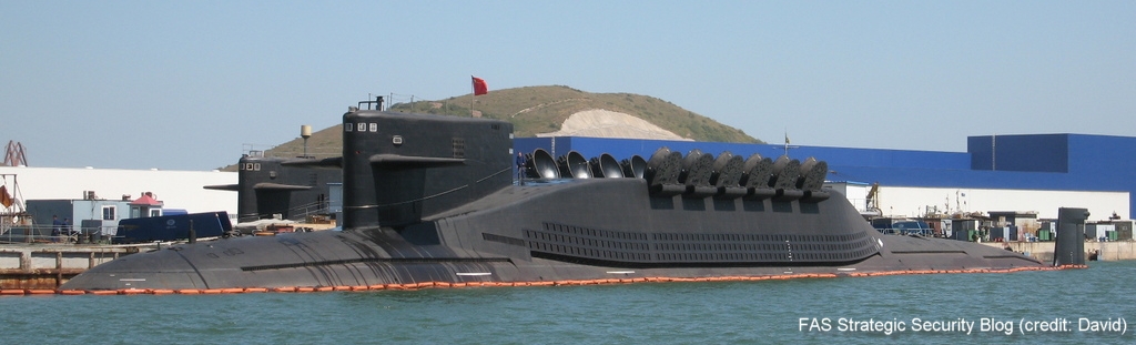
China’s new Jin-class SSBNs at Huludao shipyard. |
By Hans M. Kristensen
The two new Jin-class SSBNs I discovered on Google Earth earlier this month have now been photographed in port by an anonymous photographer. The photograph, which has appeared on several Chinese web sites (here and here) and sent to me by David, clearly shows the features of what I estimated to be the Jin-class submarine.
Nothing is known about who took this photograph or whether or not it has been digitally manipulated. But if it is authentic, it appears to lay to rest speculations that the Jin-class would carry 16 missiles. Instead the photograph confirms the assessment made by the U.S. intelligence community by clearly showing the wide-open hatches of 12 launch tubes.
The photograph shows the submarines at an angle, which makes it difficult to precisely measure the length of the various sections. Furthermore, he second submarine on the other side of the pier is obscured by the submarine closest to the camera, making comparison of the two impossible. Yet, a comparison made from the satellite images on my previous blog show that the two submarines have the same overall dimensions.
The new photograph shows the sail of both submarines, which appear to be very similar. Moreover, the front submarine shows a unique feature on the top of the rudder section, which may be a sensor of some kind.
Overall, it is not as if the Chinese are trying to hide anything. Indeed, it is almost as if they want to show what they’ve got.
Background: Chinese Nuclear Forces and U.S. Nuclear War Planning
The last remaining agreement limiting U.S. and Russian nuclear weapons has now expired. For the first time since 1972, there is no treaty-bound cap on strategic nuclear weapons.
The Pentagon’s new report provides additional context and useful perspectives on events in China that took place over the past year.
Successful NC3 modernization must do more than update hardware and software: it must integrate emerging technologies in ways that enhance resilience, ensure meaningful human control, and preserve strategic stability.
The FY2026 National Defense Authorization Act (NDAA) paints a picture of a Congress that is working to both protect and accelerate nuclear modernization programs while simultaneously lacking trust in the Pentagon and the Department of Energy to execute them.