Clean Water: Protecting New York State Private Wells from PFAS
This memo responds to a policy need at the state level that originates due to a lack of relevant federal data. The Environmental Protection Agency (EPA) has a learning agenda question that asks,“To what extent does EPA have ready access to data to measure drinking water compliance reliably and accurately?” This memo fills that need because EPA doesn’t measure private wells.
Per- and polyfluoroalkyl substances (PFAS) are widely distributed in the environment, in many cases including the contamination of private water wells. Given their links to numerous serious health consequences, initiatives to mitigate PFAS exposure among New York State (NYS) residents reliant on private wells were included among the priorities outlined in the annual State of the State address and have been proposed in state legislation. We therefore performed a scenario analysis exploring the impacts and costs of a statewide program testing private wells for PFAS and reimbursing the installation of point of entry treatment (POET) filtration systems where exceedances occur.
Challenge and Opportunity
Why care about PFAS?
Per- and polyfluoroalkyl substances (PFAS), a class of chemicals containing millions of individual compounds, are of grave concern due to their association with numerous serious health consequences. A 2022 consensus study report by the National Academies of Sciences, Engineering, and Medicine categorized various PFAS-related health outcomes based on critical appraisal of existing evidence from prior studies; this committee of experts concluded that there is high confidence of an association between PFAS exposure and (1) decreased antibody response (a key aspect of immune function, including response to vaccines) (2) dyslipidemia (abnormal fat levels in one’s blood), (3) decreased fetal and infant growth, and (4) kidney cancer, and moderate confidence of an association between PFAS exposure and (1) breast cancer, (2) liver enzyme alterations, (3) pregnancy-induced high blood pressure, (4) thyroid disease, and (5) ulcerative colitis (an autoimmune inflammatory bowel disease).
Extensive industrial use has rendered these contaminants virtually ubiquitous in both the environment and humans, with greater than 95% of the U.S. general population having detectable PFAS in their blood. PFAS take years to be eliminated from the human body once exposure has occurred, earning their nickname as “forever chemicals.”
Why focus on private drinking water?
Drinking water is a common source of exposure.
Drinking water is a primary pathway of human exposure. Combining both public and private systems, it is estimated that approximately 45% of U.S. drinking water sources contain at least one PFAS. Rates specific to private water supplies have varied depending on location and thresholds used. Sampling in Wisconsin revealed that 71% of private wells contained at least one PFAS and 4% contained levels of perfluorooctanoic acid (PFOA) or perfluorooctanesulfonic acid (PFOS), two common PFAS compounds, exceeding Environmental Protection Agency (EPA)’s Maximum Contaminant Levels (MCLs) of 4 ng/L. Sampling in New Hampshire, meanwhile, found that 39% of private wells exceeded the state’s Ambient Groundwater Quality Standards (AGQS), which were established in 2019 and range from 11-18 ng/L depending on the specific PFAS compound. Notably, while the EPA MCLs represent legally enforceable levels accounting for the feasibility of remediation, the agency has also released health-based, non-enforceable Maximum Contaminant Level Goals (MCLGs) of zero for PFOA and PFOS.
PFAS in private water are unregulated and expensive to remediate.
In New York State (NYS), nearly one million households rely on private wells for drinking water; despite this, there are currently no standardized well testing procedures and effective well water treatment is unaffordable to many New Yorkers. As of April 2024, the EPA has established federal MCLs for several specific PFAS compounds and mixtures of compounds and its National Primary Drinking Water Regulations (NPDWR) require public water systems to begin monitoring and publicly reporting levels of these PFAS by 2027; if monitoring reveals exceedances of the MCLs, public water systems must also implement solutions to reduce PFAS by 2029. In contrast, there are no standardized testing procedures or enforceable limits for PFAS in private water. Additionally, testing and remediating private wells are both associated with high costs which are unaffordable to many well owners; prices range in hundreds of dollars for PFAS testing and can cost several thousands of dollars for the installation and maintenance of effective filtration systems.
How are states responding to the problem of PFAS in private drinking water?
Several states, including Colorado, New Hampshire, and North Carolina, have already initiated programs offering well testing and financial assistance for filters to protect against PFAS.
- After piloting its PFAS Testing and Assistance (TAP) program in one county in 2024, Colorado will expand it to three additional counties in 2025. The program covers the expenses of testing and a $79 nano pitcher (point-of-use) filter. Residents are eligible if PFOA and/or PFOS in their wells exceeds EPA MCLs of 4 ng/L; filters are free if their household income is ≤80% of the area median income and offered at a 30% discount if this income criteria is not met.
- The New Hampshire (NH) PFAS Removal Rebate Program for Private Wells offers greater flexibility and higher cost coverage than Colorado PFAS TAP, with reimbursements of up to $5000 offered for either point-of-entry or point-of-use treatment system installation and up to $10,000 offered for connection to a public water system. Though other residents may also participate in the program and receive delayed reimbursement, households earning ≤80% of the area median family income are offered the additional assistance of payment directly to a treatment installer or contractor (prior to installation) so as to relieve the applicant of fronting the cost. Eligibility is based on testing showing exceedances of the EPA MCLs of 4 ng/L for PFOA or PFOS or 10 ng/L for PFHxS, PFNA, or HFPO-DA (trademarked as “GenX”).
- The North Carolina PFAS Treatment System Assistance Program offers flexibility similar to New Hampshire in terms of the types of water treatment reimbursed, including multiple point-of-entry and point-of-use filter options as well as connection to public water systems. It is additionally notable for its tiered funding system, with reimbursement amounts ranging from $375 to $10,000 based on both the household’s income and the type of water treatment chosen. The tiered system categorizes program participants based on whether their household income is (1) <200%, (2) 200-400%, or (3) >400% the Federal Poverty Level (FPL). Also similar to New Hampshire, payments may be made directly to contractors prior to installation for the lowest income bracket, who qualify for full installation costs; others are reimbursed after the fact. This program uses the aforementioned EPA MCLs for PFOA, PFOS, PFHxS, PFNA, or HFPO-DA (“GenX”) and also recognizes the additional EPA MCL of a hazard index of 1.0 for mixtures containing two or more of PFHxS, PFNA, HFPO-DA, or PFBS.
An opportunity exists to protect New Yorkers.
Launching a program in New York similar to those initiated in Colorado, New Hampshire, and North Carolina was among the priority initiatives described by New York Governor Kathy Hochul in the annual State of the State she delivered in January 2025. In particular, Hochul’s plans to improve water infrastructure included “a pilot program providing financial assistance for private well owners to replace or treat contaminated wells.” This was announced along with a $500 million additional investment beyond New York’s existing $5.5 billion dedicated to water infrastructure, which will also be used to “reduce water bills, combat flooding, restore waterways, and replace lead service lines to protect vulnerable populations, particularly children in underserved communities.” In early 2025, the New York Legislature introduced Senate Bill S3972, which intended to establish an installation grant program and a maintenance rebate program for PFAS removal treatment. Bipartisan interest in protecting the public from PFAS-contaminated drinking water is further evidenced by a hearing focused on the topic held by the NYS Assembly in November 2024.
Though these efforts would likely initially be confined to a smaller pilot program with limited geographic scope, such a pilot program would aim to inform a broader, statewide intervention. Challenges to planning an intervention of this scope include uncertainty surrounding both the total funding which would be allotted to such a program and its total costs. These costs will be dependent on factors such as the eligibility criteria employed by the state, the proportion of well owners who opt into sampling, and the proportion of tested wells found to have PFAS exceedances (which will further vary based on whether the state adopts EPA MCLs or NYS Department of Health MCLs, which are 10 ng/L for PFOA and PFOS). We allay the uncertainty associated with these numerous possibilities by estimating the numbers of wells serviced and associated costs under various combinations of 10 potential eligibility criteria, 5 possible rates (5, 25, 50, 75, and 100%) of PFAS testing among eligible wells, and 5 possible rates (5, 25, 50, 75, and 100%) of PFAS>MCL and subsequent POET installation among wells tested.
Scenario Analysis
Key findings
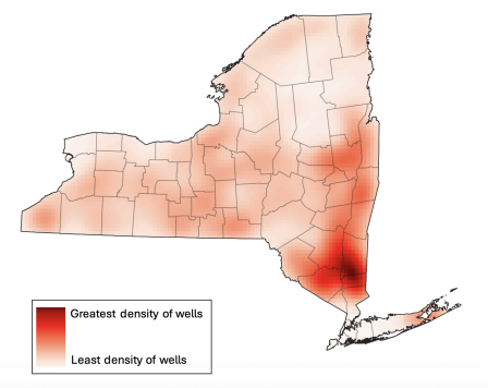
- Over 900,000 residences across NYS are supplied by private drinking wells (Figure 1).
- The three most costly scenarios were offering testing and installation rebates for (Table 1):
- Every private well owner (901,441 wells; $1,034,403,547)
- Every well located within a census tract designated as disadvantaged (based on NYS Disadvantaged Community (DAC) criteria) AND/OR belonging to a household with annual income <$150,000 (725,923 wells; $832,996,643)
- Every well belonging to a household with annual income <$150,000 (705,959 wells; $810,087,953)
- The three least costly scenarios were offering testing and installation rebates for (Table 1):
- Every well located within a census tract in which at least 51% of households earn below 80% of the area median income (22,835 wells; $26,191,688)
- Every well belonging to a household earning <100% of the Federal Poverty Level (92,661 wells; $106,328,398)
- Every well located within a census tract designated as disadvantaged (based on NYS Disadvantaged Community (DAC) criteria) (93,840 wells; $107,681,400)
- Of six income-based eligibility criteria, household income <$150,000 included the greatest number of wells, whereas location within a census tract in which at least 51% of households earn below 80% the area median income (a definition of low-to-moderate income used for programs coordinated by the U.S. Department of Housing and Urban Development), included the fewest wells. This amounts to a cost difference of $783,896,265 between these two eligibility scenarios.
- Six income-based criteria varied dramatically in terms of their inclusion of wells across NYS which fall within either disadvantaged or small communities (Table 2):
- For disadvantaged communities, this ranged from 12% (household income <100% federal poverty level) to 79% (income <$150,000) of all wells within disadvantaged communities being eligible.
- For small communities, this ranged from 2% (census tracts in which at least 51% of households earn below 80% area median income) to 83% (income <$150,000) of all wells within small communities being eligible.
Plan of Action
New York State is already considering a PFAS remediation program (e.g., Senate Bill S3972). The 2025 draft of the bill directed the New York Department of Environmental Conservation to establish an installation grant program and a maintenance rebate program for PFAS removal treatment, and establishes general eligibility criteria and per-household funding amounts. To our knowledge, S3972 did not pass in 2025, but its program provides a strong foundation for potential future action. Our suggestions below resolve some gaps in S3972, including additional detail that could be followed by the implementing agency and overall cost estimates that could be used by the Legislature when considering overall financial impacts.
Recommendation 1. Remediate all disadvantaged wells statewide
We recommend including every well located within a census tract designated as disadvantaged (based on NYS Disadvantaged Community (DAC) criteria) and/or belonging to a household with annual income <$150,000 as the eligibility criteria which protects the widest range of vulnerable New Yorkers. Using this criteria, we estimate a total program cost of approximately $833 million, or $167 million per year if the program were to be implemented over a 5-year period. Even accounting for the other projects which the state will be undertaking at the same time, this annual cost falls well within the additional $500 million which the 2025 State of the State reports will be added in 2025 to an existing $5.5 million state investment in water infrastructure.
Recommendation 2. Target disadvantaged census tracts and household incomes
Wells in DAC census tracts accounts for a variety of disadvantages. Including NYS DAC criteria helps to account for the heterogeneity of challenges experienced by New Yorkers by weighing statistically meaningful thresholds for 45 different indicators across several domains. These include factors relevant to the risk of PFAS exposure, such as land use for industrial purposes and proximity to active landfills.
Wells in low-income households account for cross-sectoral disadvantage. The DAC criteria alone is imperfect:
- Major criticisms include its underrepresentation of rural communities (only 13% of rural census tracts, compared to 26% of suburban and 48% of urban tracts, have been DAC-designated) and failure to account for some key stressors relevant to rural communities (e.g., distance to food stores and in-migration/gentrification).
- Another important note is that wells within DAC communities account for only 10% of all wells within NYS (Table 2). While wells within DAC-designated communities are important to consider, including only DAC wells in an intervention would therefore be very limiting.
- Whereas DAC designation is a binary consideration for an entire census tract, place-based criteria such as this are limited in that any real community comprises a spectrum of socioeconomic status and (dis)advantage.
The inclusion of income-based criteria is useful in that financial strain is a universal indicator of resource constraint which can help to identify the most-in-need across every community. Further, including income-based criteria can widen the program’s eligibility criteria to reach a much greater proportion of well owners (Table 2). Finally, in contrast to the DAC criteria’s binary nature, income thresholds can be adjusted to include greater or fewer wells depending on final budget availability.
- Of the income thresholds evaluated, income <$150,000 is recommended due to its inclusion not only of the greatest number of well owners overall, but also the greatest percentages of wells within disadvantaged and small communities (Table 2). These two considerations are both used by the EPA in awarding grants to states for water infrastructure improvement projects.
- As an alternative to selecting one single income threshold, the state may also consider maximizing cost effectiveness by adopting a tiered rebate system similar to that used by the North Carolina PFAS Treatment System Assistance Program.
Recommendation 3. Alternatives to POETs might be more cost-effective and accessible
A final recommendation is for the state to maximize the breadth of its well remediation program by also offering reimbursements for point-of-use treatment (POUT) systems and for connecting to public water systems, not just for POET installations. While POETs are effective in PFAS removal, they require invasive changes to household plumbing and prohibitively expensive ongoing maintenance, two factors which may give well owners pause even if they are eligible for an initial installation rebate. Colorado’s PFAS TAP program models a less invasive and extremely cost-effective POUT alternative to POETs. We estimate that if NYS were to provide the same POUT filters as Colorado, the total cost of the program (using the recommended eligibility criteria of location within a DAC-designated census tract and/or belonging to a household with annual income <$150,000) would be $163 million, or $33 million per year across 5 years. This amounts to a total decrease in cost of nearly $670 million if POUTs were to be provided in place of POETs. Connection to public water systems, on the other hand, though a significant initial investment, provides an opportunity to streamline drinking water monitoring and remediation moving forward and eliminates the need for ongoing and costly individual interventions and maintenance.
Conclusion
Well testing and rebate programs provide an opportunity to take preventative action against the serious health threats associated with PFAS exposure through private drinking water. Individuals reliant on PFAS-contaminated private wells for drinking water are likely to ingest the chemicals on a daily basis. There is therefore no time to waste in taking action to break this chain of exposure. New York State policymakers are already engaged in developing this policy solution; our recommendations can help both those making the policy and those tasked with implementing it to best serve New Yorkers. Our analysis shows that a program to mitigate PFAS in private drinking water is well within scope of current action and that fair implementation of such a program can help those who need it most and do so in a cost-effective manner.
While the Safe Drinking Water Act regulates the United States’ public drinking water supplies, there is no current federal government to regulate private wells. Most states also lack regulation of private wells. Introducing new legislation to change this would require significant time and political will. Political will to enact such a change is unlikely given resource limitations, concerns around well owners’ privacy, and the current time in which the EPA is prioritizing deregulation.
Decreasing blood serum levels is likely to decrease negative health impacts. Exposure via drinking water is particularly associated with elevated serum PFAS levels, while appropriate water filtration has demonstrated efficacy in reducing serum PFAS levels.
We estimated total costs assuming that 75% of eligible wells are tested for PFAS and that of these tested wells, 25% are both found to have PFAS exceedances and proceed to have filter systems installed. This PFAS exceedance/POET installation rate was selected because it falls between the rates of exceedances observed when private well sampling was conducted in Wisconsin and New Hampshire in recent years.
For states which do not have their own tools for identifying disadvantaged communities, the Social Vulnerability Index developed by the Centers for Disease Control and Prevention (CDC) and Agency for Toxic Substances and Disease Registry (ATSDR) may provide an alternative option to help identify those most in need.
Soil and Water: Why We Need Conservation Agriculture
On May 1, 2023, a devastating dust storm – the result of severe wind erosion – propelled soil across highway I-55, causing numerous accidents, injuries, and loss of life. The factors that led to this erosion event were excessive tillage, exposed soils, and windy conditions. In response, the Journal of Soil and Water Conservation published an article proposing a “Soil Health Act,” to improve conservation agriculture policy.
Most erosion is a direct result of human activities, such as leaving the soil bare for extended periods and excessive tillage in agricultural fields. Extreme weather events exacerbate soil erosion, with large wind erosion events damaging crops and causing air pollution in nearby communities. Water erosion can strip productive topsoil from cropland, reducing crop productivity and depositing sediment in water bodies. The Fifth National Climate Assessment further confirms that extreme weather is on the rise.
The United States boasts some of the most productive soils globally, particularly in the Midwest region, known as the corn belt. This vast expanse of farmland, which drains into the Mississippi River and eventually reaches the Gulf of Mexico, is a crucial part of our country’s agricultural landscape. However, this network of soil and water, while offering significant benefits, also poses significant challenges if not properly cared for.
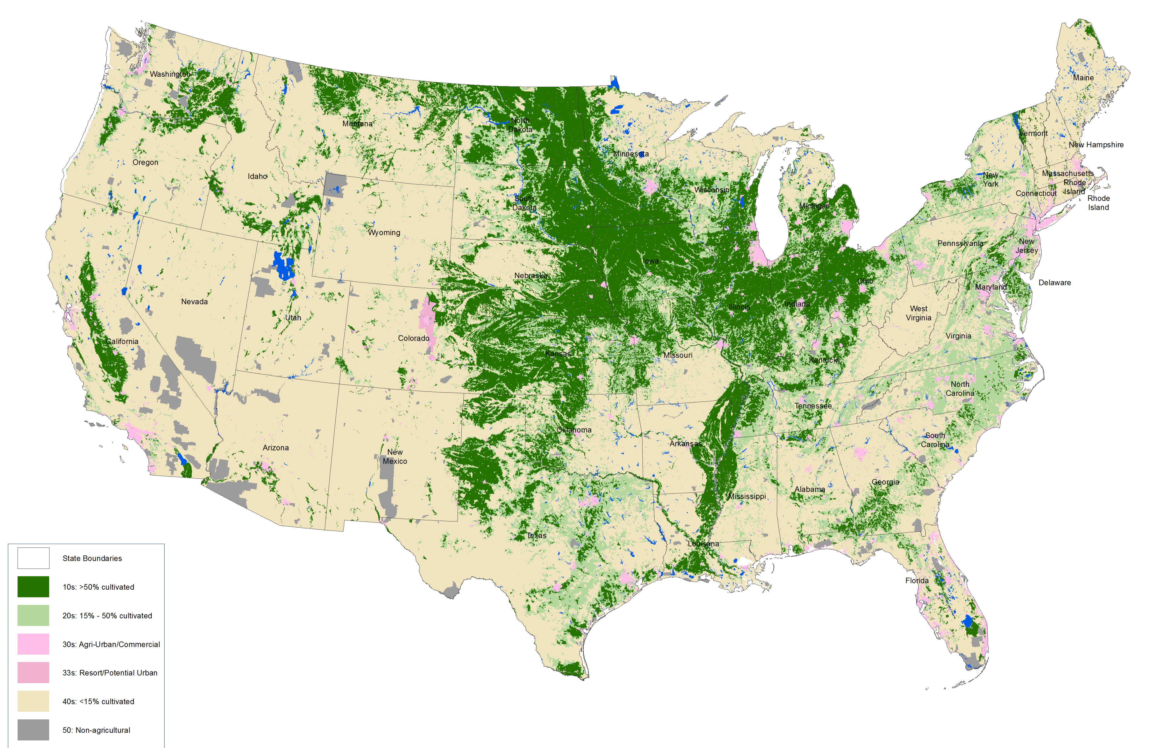
Map of U.S. major agriculture cropland areas in dark green. These regions also have highly productive soils. The Midwest soils of Iowa, southern Minnesota, Illinois, Indiana, southern Wisconsin, and Ohio are globally significant breadbasket soils. (Source: National Agricultural Statistics Service, 2017).
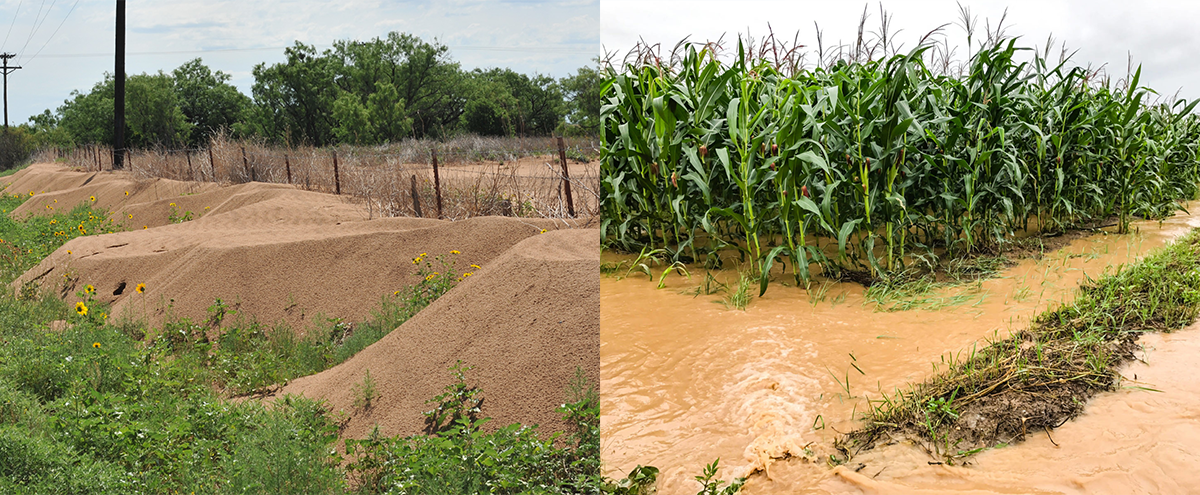
Wind erosion in the left photo is active in many regions of the country, leading to poor soil conditions for agricultural production. Water erosion takes productive topsoil and applied fertilizers and chemical products used off cropland as it heads toward streams. (Source: Jodie McVane (left) and Rodale Institute (right))
Fertilizers, herbicides, pesticides, and other products can enter water sources through two primary pathways: soil and chemical losses. Chemical losses can contaminate groundwater by moving down through the soil profile. Contaminated groundwater flows into private and public water supply wells , with many wells having high nitrate levels from commercial fertilizers and animal applications of manure. Nitrates can pose health risks to infants, cause toxic anemia, and how red blood cells deliver oxygen to the cells and tissues. In adults, reproductive health issues and certain cancers are also possible. And it’s not just nitrates: Atrazine, a common chemical used to control weeds, is found in many drinking wells across the U.S.
When soil erodes it takes nitrates, atrazine, and other contaminants away from land surfaces and into surface waterways, leading to water quality problems and soil sediment pollution. Many land managers try to avoid creating runoff, but agricultural practices leaving soils exposed with no plant residues and erosive storms make this a common occurrence. Soil erosion impacts can also be experienced as sedimentation and murky waters in recreational water bodies, roads covered with mud, and dirty snow covered with wind-blown soils, all of which affect everyday life and are undesirable for fish and plants. The lack of soil protection during the non-crop growing season in the U.S. has caused soil erosion and degradation of precious resources, diminishing the ability to grow food, fiber, and wood and provide clean water. Thus, erosion affects long-term production and economic viability for farms.
Protecting Our Soils Through Conservation Agriculture
Fortunately, we can find solutions through conservation agriculture–a system of farming practices, which includes cover crops and reduced tillage, that protects soil and prevents both soil and chemical losses. Growing plants year-round can address soil loss by keeping the soil covered with plants known as cover crops like corn, soybean, and cotton. Others, like grasses, legumes, and forbs can be grown for seasonal cover. Reduced tillage from cover crops can be beneficial in several different ways:
They control erosion, build healthy soils, and improve water quality. Cover crops planted during these periods can scavenge unused fertilizers from the previous crop and prevent nutrients from reaching surface and groundwater systems. Reducing tillage or switching to no-till cropping systems can also increase soil structure and aid in water infiltration, helping water get into the soil instead of running off.
When soils have many soil organisms with a favorable habitat, they can break down chemical pollutants effectively before reaching groundwater. Cover crops can also play a vital role in absorbing nitrates or other contaminants. Studies have shown that cover crops can reduce nitrates by 48% before they reach subsurface waters. Reduced tillage can provide habitats for these organisms by reducing soil disturbance.
Cover crops capture sunlight and use plants’ photosynthetic processes to capture carbon in plant shoots and root systems. Much carbon is stored in our soils through plant roots. When the plants die, their roots remain in the soil, keeping the carbon sequestered. Excessive tillage breaks soil structure and releases carbon. Reduced tillage and no-till cropping systems allow soils to better maintain their carbon content.
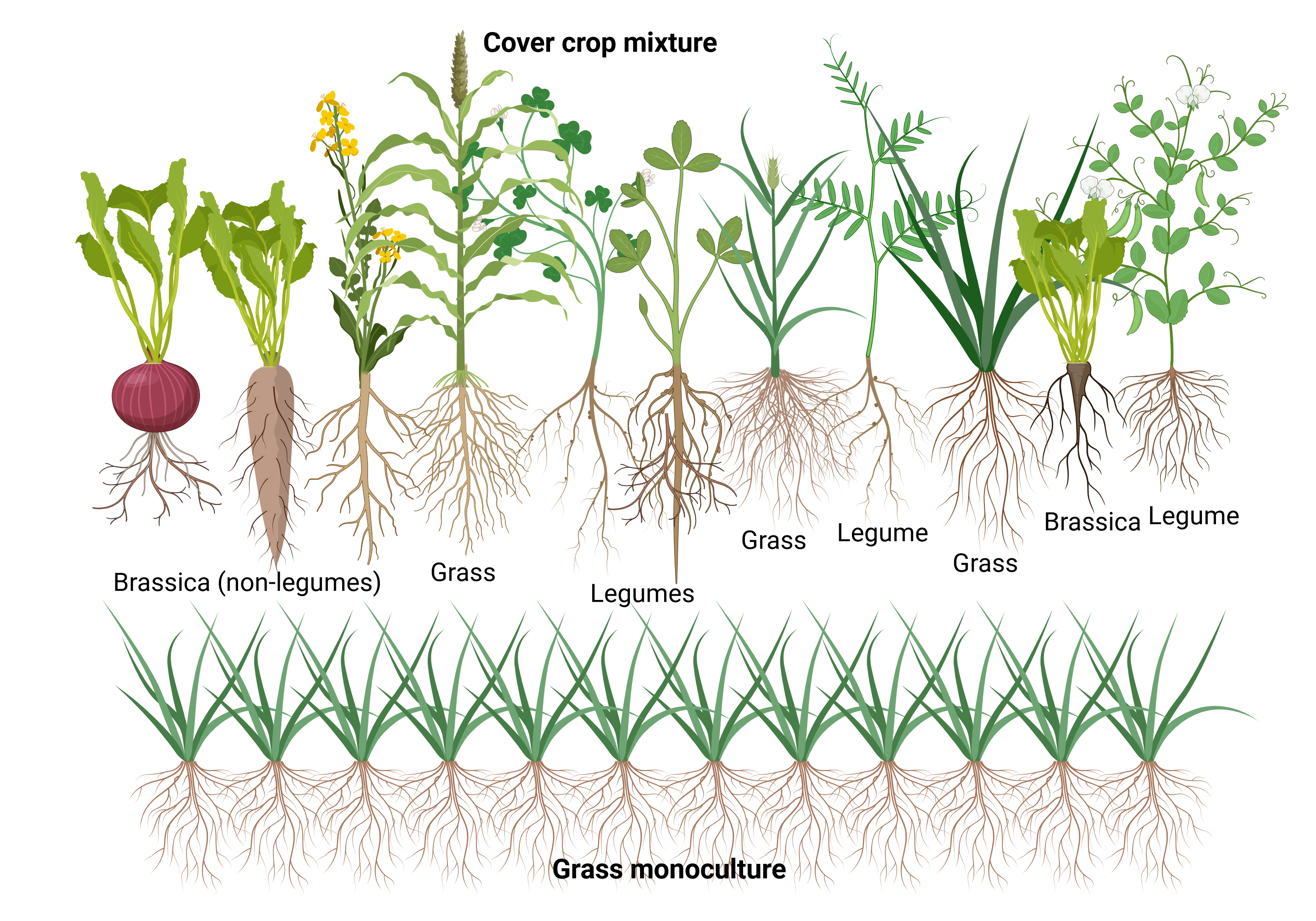
Diverse cover crop species can be mixed, which leads to the diversification of plant roots and above-ground biomass. Furthermore, diversity above ground also means diversity below ground for soil organisms. Grasses can also be utilized alone to effectively suppress weeds and protect against erosion. Cover crops can capture carbon and increase carbon storage in soils, so planting cover crops yearly is important. (Source: Jodie McVane)
Federal and State Government Incentives to Expand Conservation Agricultural Practices
Overall, cover crop use is low in the United States and varies depending on established social norms, soils, climate, primary crops, outreach programs, and conservation technical assistance. According to the USDA Economic Research Service, cover crop use increased from 3.4% of U.S. cropland in 2012 to 5.1% in 2017. The increase is positive, but millions of cropland acres can still benefit from applying cover crops and reduced tillage. While the use of conservation agriculture is an individual land manager’s choice and overall cover crop remains low, the USDA report notes that there has been some progress and positive trends. Continued incentives from both federal and state governments will be crucial to encourage wide adoption of conservation agricultural practices.
Many USDA programs provide cost-sharing incentives to farmers who voluntarily encourage using cover crops, reducing tillage, planting grasslands, and diversifying crop rotations. The Farm Bill provides funding to assist farmers through the USDA-Natural Resources Conservation Service (USDA-NRCS) programs, such as the Environmental Quality Incentive Program (EQIP) and the Conservation Stewardship Program (CSP). In addition to the Farm Bill, the Inflation Reduction Act provided additional funds to USDA-NRCS through these same programs to promote Climate Smart Agriculture and Forestry Mitigation activities. The Inflation Reduction Act makes nearly $20 billion additional dollars available over five years for these programs. Current federal policy allows these programs to fund conservation practices for 3-5 years on a typical farm. Some states are also leading in incentivizing land managers to apply cover crops. States providing monetary incentives include Maryland, Iowa, Missouri, Indiana, Ohio, and Virginia.
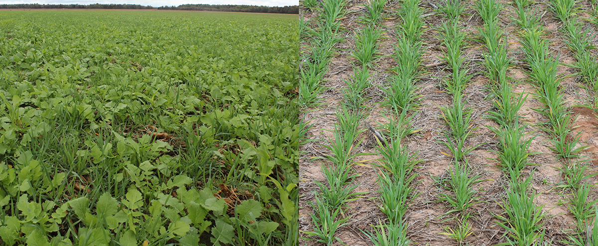
A mix of cover crops of grasses and broadleaves in the fall after a corn crop in the Midwest. (left photo) A cereal ryegrass cover crop holds the soil in place with fibrous root systems and protects the soil surface from water or wind erosion while suppressing weeds. (right photo) (Source: Jodie McVane)
Current Gaps and Proposed Policies
We will need lasting policies and sustainable funding to ensure the long-term adoption of conservation agricultural practices. Current voluntary conservation programs only provide funding for a 5-year period, which does not guarantee that farmers will permanently transition to conservation agriculture practices.
The federal government should incentivize the adoption of soil health practices and conservation agriculture widely across the United States in three ways:
Fund organizations that can provide educational events for farmers, consultants, policy groups, and consumers. These organizations are valuable and promote farmer-led education and peer-to-peer mentoring. Farmers enjoy learning from other farmers along with research experts.
Reward farmers who adopt conservation agriculture systems by providing long-term payments for continued use of conservation practices. Farmers who adopt these practices would benefit from their ecosystem services, such as building soil carbon, improving water quality, maintaining stable soil structure, and increasing water infiltration, which could significantly impact the health of our cropland acres.
Provide a reduction-based premium discount in the Federal Crop Insurance program for agricultural commodity producers that use risk-reduction farming practices, including cover crops. A discount on the insurance premium can have a lasting effect and provide a continued financial incentive to perform conservation on farms.
Soil is the foundation of our national health, providing food, homes, fibers, and the structural foundations for everyday life. Soils filter water for clean drinking, safe fishing, and other recreational activities, enabling our farms, factories, homes, schools, universities, and state and federal governments to access clean water; the widespread adoption of conservation agricultural practices to protect soils is key to ensuring food security for current and future generations in the United States. Healthy soils can protect not only our national treasure but also our national security and ability to care for our citizens.
As President Franklin D. Roosevelt said, “The nation that destroys its soil destroys itself.” Imagine driving around the country and seeing continuous vegetation growing, protecting soils, capturing carbon, and protecting our water resources. It would be a different landscape in our nation and, over the years, could improve the culture of agriculture.
The Federation of American Scientists values diversity of thought and believes that a range of perspectives — informed by evidence — is essential for discourse on scientific and societal issues. Contributors allow us to foster a broader and more inclusive conversation. We encourage constructive discussion around the topics we care about.
U.S. Water Policy for a Warming Planet
In 2000, Fortune magazine observed, “Water promises to be to the 21st century what oil was to the 20th century: the precious commodity that determines the wealth of nations.” Like petroleum, freshwater resources vary across the globe. Unlike petroleum, no living creature survives long without it. Recent global episodes of extreme heat intensify water shortages caused by extended drought and overpumping. Creating actionable solutions to the challenges of a warming planet requires cooperation across all water consumers.
The Biden-Harris administration should work with stakeholders to (1) develop a comprehensive U.S. water policy to preserve equitable access to clean water in the face of a changing climate, extreme heat, and aridification; (2) identify and invest in agricultural improvements to address extreme heat-related challenges via U.S. Department of Agriculture (USDA) and Farm Bill funding; and (3) invest in water replenishment infrastructure and activities to maintain critical surface and subsurface reservoirs. America’s legacy water rules, developed under completely different demographic and environmental conditions than today, no longer meet the nation’s current and emerging needs. A well-conceived holistic policy will optimize water supply for agriculture, tribes, cities, recreation, and ecosystem health even as the planet warms.
Challenge and Opportunity
In 2023, the National Oceanic and Atmospheric Administration (NOAA) recorded the hottest global average temperature since records began 173 years prior. In the same year, the U.S. experienced a record 28 billion-dollar disasters. The earth system responds to increasing heat in a variety of ways, most of them involving swings in weather and water cycles. Warming air holds more moisture, increasing the possibility of severe storm events. Extreme heat also depletes soil moisture and increases evapotranspiration. Finally, warmer average temperatures across the U.S. induce northward shifts in plant hardiness zones, reshaping state economies in the process.
As a result, agriculture currently experiences billions of dollars in losses each year (Fig. 1). Drought, made worse by high heat conditions, accounts for a significant amount of the losses. In 2023, 80% of emergency disaster designations declared by USDA were for drought or excessive heat.
Agriculture consumes up to 80% of the freshwater used annually. Farmers rely on surface water and groundwater during dry conditions, as climate change systematically strains water resources. Rising heat can increase overall demand for water for irrigating crops, exacerbating water shortages. Plants need more water; evapotranspiration rates increase to keep internal temperatures in check. Warming is also shrinking the snowpack that feeds rivers, driving a “snow loss cliff” that will impact future supply. Compounding all of this, Americans have overused depleted reservoirs across the country, leading to a system in crisis.
America’s freshwater resources fall under a tangle of state, local, and watershed agreements cobbled together over the past 100 years. In general, rules fall into two main categories: riparian rights and prior appropriation. In the water-replete eastern U.S., states favor riparian rights. Under this doctrine, property owners generally maintain local use of the water running through the property or in the aquifer below it, except in the case of malicious overuse. Most riparian states currently fall under the Absolute Dominion (or the English) Rule, the Correlative Rights Doctrine, or the Reasonable Use Rule, and many use term-limited permitting to regulate water rights (Table 1). In the arid western region, states prefer the Doctrine of Prior Appropriation. Under this scheme, termed “first in time, first in right,” property owners with older claims have priority over all newer claimants. Unlike riparian rights, prior appropriation claims may be separated from the land and sold or leased elsewhere. Part of the rationale for this is that prior appropriation claims refer to shares of water that must be transported to the land via canals or pipes, rather than water that exists natively on the property, as found in the riparian case. Some states use a mix of the two approaches, and some maintain separate groundwater and surface water rules (Fig. 2).
Original “use it or lose it” rules required claimants to take their entire water allotment as a hedge against speculation by absentee owners. While persistent drought and overuse reduced water availability over time, “use it or lose it” rules continue to penalize reduction in usage rates, making efficiency counterproductive. For example, Colorado’s “use it or lose it”’ rule remains on the books, despite repeated efforts to revise it. In a sign of progress, in 2021, Arizona passed a bipartisan law to change their “use it or lose it” rule to guarantee continued water rights if users choose to conserve water.
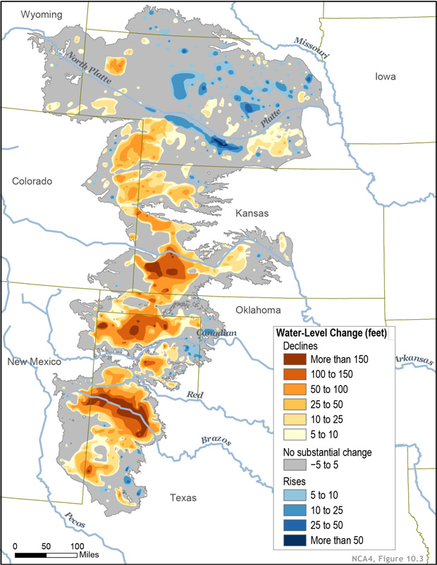
Water scarcity extends well beyond the arid western states. In the Midwest, higher temperatures and drought exacerbate overpumping that continues to deplete the vast Ogallala Reservoir that underlies the Great Plains (Fig. 3). Driven in part by rising temperatures, the effective 100th meridian that separates the arid West from the humid East appears to have shifted east by about 140 miles since 1980, indicating creeping aridification across the Midwest. The drought-impacted Mississippi River level dropped for the past two consecutive years, impeding river transport and causing saltwater intrusion into Louisiana groundwater, contaminating formerly potable water in many wells.
via Climate.gov
Recognition of water’s increased importance, especially in a future of more extreme heat and its cascading impacts, drives new markets for the trade of physical water. The impetus for some markets arises from the variance in water availability and cost between different industries and communities. Ideally, benefits accrue to both sellers and buyers by offering a valuable revenue stream for meeting a resource need. Markets differ between groundwater and surface water. For groundwater markets, agreements allow one user to trade some portion of allocated pumping rights to another local user, although impacts to neighbors and ecosystems that share the aquifer must be considered. Successful groundwater trades rely on accurate assessments of subsurface water levels over time. For surface water trades, a portion of the prior appropriation water can be sold or leased to another user regardless of proximity, or banked for future use. Legislation passed in 2022 enables Colorado River Indian Tribes to lease or trade newly settled water rights, or to bank them for future use in surface or subsurface reservoirs without facing a “use it or lose it” penalty.
There are less obvious water considerations. Import from and export to foreign nations of heavily irrigated crops or water-intensive commodities equates to virtual water trade. The most common virtual water export involves foreign sale of American farmer-grown crops. Other means include sales or leases of domestic land to foreign entities that grow water-intensive crops on U.S. soil, often on arid land, for export. Virtual water trades occur within the U.S. as well, through exchange of goods and services.
Developing a framework for cooperation across end users, complementary to previous frameworks recommended for the Ogallala Aquifer, creates a mechanism to address urgent water issues. Establishing the federal government’s role to convene and collaborate with stakeholders helps all parties participate within a common structure toward solving a mutual problem. To promote sustained productivity and water resources in the face of extreme heat and aridification, a holistic federal water policy should focus on:
- Simplifying and streamlining water rights
- Creating a framework for water trades
- Increasing water use efficiency
- Developing data-driven predictive tools
- Initiating and supporting new agricultural approaches
- Developing strategic water recharge
The Biden-Harris administration should develop a plan that creates incentives for all stakeholders to participate in water management policy development in the face of rising heat and climate change. Specifically, discussions must consider real reservoir volumes (surface and subsurface), current and future temperatures, annual rain and snow measurements, evapotranspiration calculations, and estimates of current and future water needs and trades across all end users. History supports federal assistance in thorny resource management areas. One close analog, that of fisheries management, shows the power of compromise to conserve future resources despite fierce competition.
Plan of Action
Recommendation 1. The White House Council on Environmental Quality should convene a working group of experts from across federal and state agencies to develop a National Water Policy to future-proof water resources for a hotter nation.
Progress toward increased scientific understanding of the large-scale hydrologic cycle offers new opportunities for managing resources in the face of change. Management efforts started at local scales and expanded to regional scales. Country-wide management requires a more holistic view. The U.S. water budget is moving to a more unstable regime. Climate change and extreme heat add complexity by shifting weather and water cycles in real-time. Improving the system balance requires convening stakeholders and experts to formulate a high-level policy framework that:
- Creates mechanisms for cooperation across all stakeholders
- Coordinates with stakeholders to restructure water rights at the basin scale, including high-demand industries like agriculture
- Accounts for changes in total, and basin- and aquifer-scale, water volumes at the necessary spatial and temporal resolution as a basis for decision-making, including estimations of future water capacity
- Develops a mechanism to assess and manage, when necessary, physical and virtual water trades, considering climate risk to supply and demand
- Identifies opportunities for investment based on observations and best-in-class models
- Includes a framework for adaptive policy modification as climate changes, heat’s impacts are better understood, and new water trends occur
- Monitors and evaluates emerging markets to “buy” water to “bank” it for sale at a higher price during drought years and/or high heat events
- Identifies one lead government agency to coordinate water policy, nominally the Department of the Interior (DOI)
- Coordinates with Congress to identify a lead committee in each chamber to oversee water policy
As such, the White House Council on Environmental Quality should convene a working group of experts from across federal and state agencies to create a comprehensive National Water Policy. Relevant government agencies include the DOI; the U.S. Geological Survey (USGS); the Bureau of Indian Affairs; the U.S. Army Corps of Engineers (USACE); Federal Emergency Management Agency (FEMA); Department of Commerce; NOAA; and the USDA. The envisioned National Water Policy complements the U.S. Government Global Water Strategy.
via USGS
Data products to support the creation of a robust National Water Policy already exist (Fig. 4). USGS, FEMA, the National Weather Service, USDA’s Natural Resources Conservation Service, and NOAA’s National Climate Data Center, Office of Water Prediction, and National Water Center all contribute data critical to development of both high-level and regional-scale assessments and data layers crucial for short- and mid-term planning. Creating term reassessments as more data accrue and models improve supports effective decision-making as climate change and extreme heat continue to alter the hydrologic cycle. An overall water policy must remain dynamic due to changing trends and new data.
National, regional, and local aspects of the water budget and related models and visualizations help federal and state decision makers develop a strategic plan for modernizing water rights for both river water, basins, and groundwater and to identify risks to supplies (e.g., decreasing snowpack due to higher heat) and opportunities for recharge. Stakeholders and water managers with shared knowledge of well-documented data are best positioned to determine minimum reservoir volumes in the primary storage basins, including aquifers, in alignment with the objectives of the National Strategy to Develop Statistics for Environmental and Economic Decisions. By creating a strategy that uses actual average values to maintain reservoir volumes, some of the potential shocks created by drought years and high heat could be cushioned, and related financial losses could be avoided or mitigated. Ultimately, stakeholders and managers must share a common understanding of the water budget when seeking to resolve water rights disputes, to review and revise water rights, and to inform trades.
Basin and local data promote development of a strategic framework for water trades. As trades and markets continue to grow, states and municipalities must account for water rights, both the lease and sale of rights, to buffer large fluctuations in water prices and availability. Emerging markets to “buy” water to “bank” it for sale at a higher price during drought years and/or high heat events should also be monitored and evaluated by relevant agencies like Commerce. States’ and investors’ maintenance of transparency around market activities, including investor purchases of land with water rights, promotes fair trade and ensures stakeholder confidence in the process.
Finally, to communicate clearly with the public, funds should be provided through the DOI budget to NOAA and USGS data scientists to create decision-support tools that build on the work already underway through mature databases (e.g., at drought.gov and water.weather.gov). New water visualization tools to show the nowcast and forecast of the national water status would help the public understand policy decisions, akin to depictions used by weather forecasters. Variables should include heat index, humidity, expected evapotranspiration, precipitation, surface volumes, and groundwater levels, along with information on water use restrictions and recharge mechanisms at the local level. Making this product media-friendly aids public education and bolsters policy adoption and acceptance.
Recommendation 2. USDA should invest in infrastructure, research, and development.
Agriculture, as the largest water consumer, faces scarcity in the coming years even as populations continue to grow. Increasing demands on a dwindling resource and growing need for more water lead to conflict and acrimony. To ease tensions and maintain the goods and services needed to fuel the U.S. economy in the future, investment in both immediately practicable future-proofed, heat-resilient water solutions and over-the-horizon research and development must commence. To prepare, USDA will need to:
- Continue to fund the installation of liners or pipes for irrigation and conveyance canals, in alignment with efforts under the Bipartisan Infrastructure Law (BIL). Farmers historically irrigated their fields by flooding them via outdated earthen canals. Extensive evaporation and ground seepage losses delay water delivery to fields and creates unintended ecological side effects.
- Promote the installation of water-efficient irrigation methods on farms that previously used field flooding or other inefficient practices. Policy may include co-funding improvements, buying back “conserved water” and offering low-interest loans. The combination of improved canals with efficient irrigation technologies maintains agricultural production while reducing water loss.
- Test the efficacy of installing solar panels over or adjacent to open lined aqueducts or conveyance canals to both produce energy by taking advantage of evaporative cooling of the panel undersides and reduce some heat-driven evaporation of water from the canal by blocking sunlight. The dual benefit especially increases in the face of extreme heat where panels ordinarily become much less efficient as temperatures rise. An additional advantage includes running electrical infrastructure out to farms where farmers could use energy or connect their own panels if they wished to sell energy back to the grid.
- Add agrivoltaics (or other emerging energy/agricultural land use options) to the Agricultural Conservation Easement Program (ACEP). Research indicates that co-benefits include locally increased moisture for plants protected by panels while evapotranspiration cools the panels. This adaptation creates a reliable source of local energy while keeping agricultural land productive.
- Support transition to USDA-recommended varieties of climate-resilient Western native grasses for forage and soil stabilization of marginal land. Converting some highly irrigated farmland to desert livestock forage maintains agricultural land while reducing water usage, in line with the goals of the ACEP program.
- Support market development for desert agricultural crops adapted to the native conditions under the new Regional Agricultural Promotion Program (RAPP). Include food science and animal feed research to increase adoption. Examples include cactus opuntia fruit for natural sweetening, cactus paddles for food and fodder, drought-tolerant grasses and grains, mesquite grass forage, and mesquite bush seed pod flour. These developments build on careful research and accounts of Indigenous people and early settler practices and diets.
- Support development and deployment of technology that remotely detects water-stressed, heat-stressed plants to enable smart irrigation and cooling under USDA’s Agriculture and Food Research Initiative (AFRI).
- Develop crops with greater resilience to extreme heat, intermittent flooding, and intermittent drought via funding through Agriculture Advanced Research and Development Authority (AgARDA) and AFRI. Examples include genetically modifying or hybridizing plants for:
- greater heat-tolerance and resilience to heat-stress,
- adaptation to inundation-related oxygen deficiency, and
- resilience to increased heat driving evapotranspiration during droughts.
To support these efforts and broader climate resilience needs of farmers, Congress can:
- Reauthorize and fully fund the AgARDA at the requested $50 million annual budget to begin its mission. AgARDA was originally established under the 2018 Farm Bill (Section 7132 of the Agricultural Improvement Act of 2018(Public Law 115-334)). The agency received $1 million in each of the years 2022 and 2023, for a total of 0.8% of the total amount authorized. Addressing the challenges facing this century’s agriculture requires high-risk, high-reward thinking. No mechanism within the USDA sponsors such programs. Historically, the $250 million total recommended budget represented less than 0.06% of the total value ($428 billion) of the 2018 Farm Bill over its five-year span.
Recommendation 3. Federal, state, and local governments must invest in replenishing water reserves.
To balance water shortage, federal, state and local governments must invest in recharging aquifers and reservoirs while also reducing losses due to flooding. Opportunities for flood basin recharge arise during wet years, especially accounting for the shift from longer, frequent, lighter rainstorms to shorter, less frequent durations of very heavy rainfall. Federal agencies currently have opportunities to leverage Inflation Reduction Act (IRA) and BIL money for replenishment, including the following:
- FEMA, DOI and USDA can encourage grantees to use, and USACE can implement, proven nature-based, physical barriers to slow down surface flow in the event of heavy precipitation and flooding. Restoring river oxbows with associated wetlands, creating tree falls and wetland horizontal levees, reintroducing beavers, and employing other nature-based solutions can improve recharge and reduce downstream flood damage by slowing release of water. These measures should be instigated with a view to improving the hydrologic cycle of streams in the drainage basin, especially those that have been heavily engineered in the past. Co-benefits of these greening interventions include reducing surface temperature, thereby benefiting humans, livestock, and crops.
Congress can further support these actions by:
- Implementing annual-enrollment, permanent floodplain easements in the 2023 US Farm Bill. As outlined in the American Rivers report, the Emergency Watershed Protection (EWP) program “received 2,210 applications, but less than 10 percent of total applications and 16 percent of flood prone acres have been enrolled.” At present, the EWP program solely provides funds following a disaster rather than as a long-term strategic investment. Adopting floodplain easements as policy would maintain soil fertility, offer flood protection for downstream properties, and help to recharge aquifers for subsequent use and safeguard against future extreme heat and drought.
- Creating mechanisms whereby farmers who flood their fields during wet years accrue credits toward water allocations in dry years. Where appropriate, farms should be funded to develop appropriately located swales and catchments to collect rainwater and irrigation runoff.
- Funding expansion of the USACE Managed Aquifer Recharge (MAR) program authorized under the 2016 Water Resources Development Act. Projects have commenced in 17 states so far. In this approach, USACE pumps surface water into aquifers for:
- Drought resilience
- Flood mitigation
- Aquatic ecosystem restoration and constructed wetlands
- Reducing saltwater intrusion
- Multi-use urban environmental restoration projects
- Funding the purchase of properties repeatedly affected by flooding to convert them into natural flood buffer areas and to support aquifer recharge zones in line with FEMA’s Public Assistance Program. Expanding this program beyond disaster response would remove vulnerable structures proactively, based on historic flood records and documented flood risk (Fig. 5). The purchase approach is distinct from the easement program that allows farmers to retain ownership of the property.
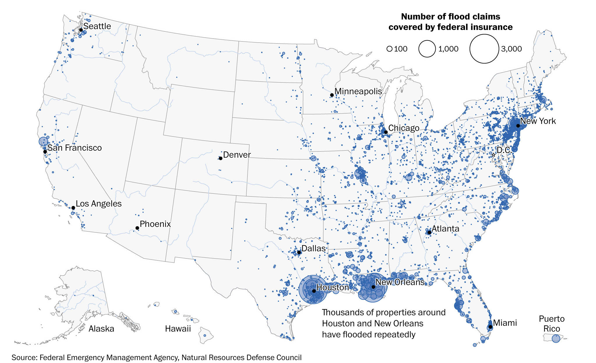
via Washington Post, with credit to Federal Emergency Management Agency, Natural Resources Defense Council
Conclusion
Water policy varies regionally, by basin, and by state. Because aquifers cross regions and water supplies vary over interstate and international boundaries, the federal government is the best arbiter for managing a dynamic, precious resource. By treating the hydrologic cycle as a dynamic system, data-driven water policy benefits all stakeholders and serves as a basis for future federal investment.
This idea of merit originated from our Extreme Heat Ideas Challenge. Scientific and technical experts across disciplines worked with FAS to develop potential solutions in various realms: infrastructure and the built environment, workforce safety and development, public health, food security and resilience, emergency planning and response, and data indices. Review ideas to combat extreme heat here.
DOI already manages surface waters in some basins through the Bureau of Reclamation and through the decision in Arizona vs. California. DOI also coordinates water infrastructure investments across multiple states via BIL funding. Furthermore, DOI agencies actively engage in collecting and sharing water resource data across the U.S. Because DOI maintains a holistic view of the hydrologic cycle and currently engages with stakeholders across the country on water concerns, it is best positioned to lead the discussions.
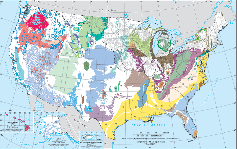
DOI, through the USGS, mapped out most of the largest U.S. aquifers (Fig. 4) and drainage basins. The main stakeholders for each reservoir emerge through those maps.
The best way to maintain agricultural production is to invest in increasingly efficient water farming practices and infrastructure. For example, installing canal liners, pipes, and smart watering equipment reduces water loss during conveyance and application. Funds have been allocated under the BIL and IRA for water infrastructure upgrades. Some government and state agencies offer grants in support of increased water efficiency. Working with seed companies to select drought- and/or flood-tolerant variants offers another approach. Farmers should also encourage funding agencies to ramp up groundwater replenishment activities and to accelerate development of new supporting technologies that will help maintain production.
Funds or tax credits are available to help defray some of the costs of installing renewable energy on rural land. Various agencies also offer targeted funding opportunities to test agrivoltaics; these opportunities tend to entail collaboration with university partners.
Over a century ago, the prior appropriation doctrine attracted homesteaders to the arid Colorado River basin by offering set water entitlements. Several early miscalculations contributed to the basin’s current water crisis. First, the average annual flow of the Colorado River used to calculate entitlements was overestimated. Second, entitlements grew to exceed the overestimated annual flow, compounding the deficit. Third, water entitlement plans failed to set aside specific shares for federally recognized tribes as well as the vast populations that responded to the call to move west. Finally, “use it or lose it” rules that govern prior appropriation entitlements created roadblocks to progress in water use efficiency.
A water futures market already exists in California.
Program leaders would need to work cooperatively with impacted families to find agreeable home sites away from flood zones, especially in close-knit communities where residents have established ties with neighbors and businesses. If desired and when practicable, existing homes could be transported to drier ground. Working with all of the stakeholders in the community to chart a path forward remains the best and most equitable policy.
Reduce, Repurpose, Recharge: Establishing a Collaborative Doctrine of Groundwater Management in the Ogallala Aquifer
Summary
Climate change has resulted in extreme and irregular rain events across the United States. Consequently, farmers in the High Plains region have been increasingly dependent on the Ogallala Aquifer for water supplies. With an estimated value of $35 billion, this aquifer supports one-fifth of the nations’ wheat, corn, cotton, and cattle. The Ogallala once held enough water to fill Chicago’s Sears Tower over 2,000 times. Today, the aquifer has lost 30% of its supply — and it is being recharged at half the rate it is being depleted. The consequence of inaction is 70% aquifer depletion by 2060, which will reduce crop output by 30–40%.

This $14 billion loss to the High Plains agricultural production may be slowed and eventually reversed by (1) reducing Ogallala use, (2) repurposing existing supplies, and (3) recharging the aquifer. The U.S. Department of Agriculture (USDA), in collaboration with the Department of the Interior (DOI) and the Federal Emergency Management Agency (FEMA), should accordingly create the Reduce, Repurpose, Recharge Initiative (RRRI), a voluntary program designed to keep farmers engaged in groundwater conservation. This multi-state program will provide financial incentives to participating farmers in exchange for pledges to limit groundwater withdrawal and participate in training that will equip them with knowledge needed to fulfill those pledges. The RRRI will also make expert advisors available to consult with farmers on policies and funding opportunities related to groundwater conservation. Finally, this program will connect farmers across state lines, allowing them to learn from each other and work together on sustainable management of the Ogallala. The program should be funded through the various water-sustainability budgets of the DOI and USDA, as well as through FEMA’s Building Resilient Infrastructure and Communities grant program.
Challenge and Opportunity
Climate-change-induced droughts have increased the nation’s dependence on groundwater as a source for agriculture, industry, and domestic use. Excessive groundwater pumping has led to land subsidence and deterioration of water quality, increasing water-use cost and jeopardizing crop yield. The problem is especially acute in the Ogallala Aquifer of the High Plains region. The aquifer underlies eight states of the nation’s breadbasket — including Nebraska, Kansas, and Texas — and spans 175,000 square miles. Dependence on the Ogallala has depleted its supply by 30% to date, as shown in Figure 1. 90% of water withdrawn from the Ogallala is used for agricultural irrigation.
Strategic plans for the USDA and DOI make it clear that drought preparedness and water conservation/sustainability are national priorities. Multiple federal efforts exist to advance these priorities. Publicly accessible platforms hosting and providing groundwater data exist at the United States Geological Survey (USGS), the National Institute of Food and Agriculture (NIFA), and the cross-agency National Integrated Drought Information System (NIDIS) partnership. The 2018 Farm Bill strengthened technical- and financial-assistance programs to help individual farms implement water-conservation technology; the bill also created an incentive program for agriculture-to-wetland conversion. From 2011–2018, the USDA’s Natural Resources Conservation Service (NRCS) ran the Ogallala Aquifer Initiative (OAI) to “support targeted, local efforts to conserve the availability of water, both its quantity and quality, in each of the States” covering the Ogallala. The OAI was successful in meeting its water-conservation goals. Recent surveys found that 93% of agricultural producers in the High Plains region believe that water conservation is important.
These past and ongoing initiatives demonstrate that federal will and stakeholder buy-in for aquifer conservation and restoration are there. The key need is for a program that provides farmers the incentives and technical assistance needed to minimize groundwater reliance, ending the tragedy of the commons in the Ogallala once and for all.
Plan of Action
USDA, DOI, and FEMA should launch a joint program designed to embed the three pillars of groundwater conservation — Reduce, Repurpose, and Recharge — into the practices of farmers in Ogallala states. The RRRI will provide a financial incentive to farmers in exchange for farmer commitments to:
- Achieve specified water-conservation targets.
- Participate in training opportunities and workshops teaching best practices for water conservation and aquifer recharge.
To succeed, the RRRI will require enthusiastic, voluntary participation from farmers across the High Plains region. Participation should be voluntary because studies have shown that voluntary programs are significantly more effective than mandates in achieving water-conservation goals. In a comparative case study about implementing
In a comparative case study about implementing a voluntary versus mandated water restriction, farmers under the voluntary restriction conserved more water relative to the mandatory regulation. A survey of these farmers attributed the group-education component of the voluntary program as the driving force for their restriction. Another survey similarly found that farmers’ altruistic views of water conservation led to longer-lasting participation in water-conservation activities. A comprehensive review of the outcomes of different water policies found that educational programs about water conservation were more effective in water use reduction and improving attitudes towards water conservation relative to mandatory water use restrictions.
To encourage voluntary participation, farmers who enroll in the RRRI would receive a financial incentive. The exact nature of the incentive would need to be determined by the implementing agencies, but could include preferential price setting, preferential market placement, or subsidies based on crop type. In exchange, farmers would agree to an initial water-use assessment performed by field experts (either employees or contractors of USDA or DOI). An appointed advisor (again, either employees or contractors of USDA or DOI) would then work with each farmer to establish long-term (5-year) water-conservation targets based on the assessment results. Each participating farmer would meet quarterly with their advisor to review their water-conservation plan, assess progress towards targets, make mutually agreeable target adjustments, and discuss challenges and solutions. Advisors would also be available in between quarterly meetings for interim questions and concerns.
Farmers who enroll in the RRRI would also commit to attending group trainings and workshops designed to help them identify and implement best water-conservation practices. These learning opportunities would be led by experts sourced from existing agricultural committees (e.g., NRCS Conservation Planners and Technical Service Providers, State Technical Committees, etc.) and water-conservation groups (e.g., Ogallala Water Coordinated Agriculture Project, Groundwater Protection Council, etc.). The group-education curriculum would cover the three tenets of groundwater conservation: reduce, repurpose, and recharge. Table 1 provides a brief description of each tenet, along with examples of aligned activities and potential sources of funding for those activities. The curriculum would teach farmers how each tenet contributes to groundwater conservation, existing and emerging technologies and practices that farmers can implement to achieve each tenet, and financial vehicles available to fund implementation. An added benefit of the group education will be the establishment of a community of farmers across the Ogallala states in which ideas and experiences can be shared.
| Tenet | Definition | Example activities | Potential funding source(s) |
| Reduce | Minimizing water needs for existing systems | More efficient irrigation | NRCS’s Agricultural Management Assistance and Conservation Innovation Grants |
| Repurpose | Move away from water-intensive practices | Switch to less water-intensive crops | NRCS’s Regional Conservation Partnership Program andConservation Stewardship Program |
| Recharge | Replenish groundwater source (aquifer) | Capture excess stormwater; convert agricultural land to wetlands | FEMA’s Building Resilient Infrastructure and Communities Grant; NRCS’s Agricultural Conservation Easement Program |
The RRRI should be established as a multi-agency collaboration. Each involved agency (USDA, DOI, and FEMA) can provide unique expertise. USDA can leverage its research arm, NIFA, to produce up-to-date technology recommendations and scientific assessments. USDA’s NRCS can provide the underlying technical and financial support for realizing the RRRI tenets. DOI can rely on USGS’s existing groundwater database and the NIDIS’s affiliated expert community of data scientists to support the granular, up-to-date groundwater measurements needed to assess water-conservation progress. DOI’s Bureau of Land Management (BLM) can ensure the RRRI tenets are enacted (in parallel with implementation on privately owned farmland) across public lands in the High Plains region. Finally, FEMA can collaborate with NIDIS and with USDA’s Risk Management Agency (RMA) to formally assess risks of drought and Ogallala depletion — assessments that can be used to make the case for the RRRI to farmers, funders, and policymakers.
Early actions needed to launch the RRRI include:
- Appoint a joint USDA/DOI task force to refine program goals and implementation strategy.
- Create teams of technical and financial experts to build the group-education curriculum.
- Identify people working at the interface of water conservation, land use, and drought preparedness who could serve as potential advisors.
- Recruit an initial cohort of farmers for a pilot version of the program. One pool to draw on for initial recruitment consists of the respondents to Lauer and Sanderson’s 2019 survey of producer attitudes in the Ogallala region.
- Socialize the proposal for RRRI with the House Agriculture Committee staff for authorization. The RRRI would fit well as part of the upcoming (in 2023) Farm Bill renewal.
Conclusion
Climate-change-induced droughts have increased farmer dependence on groundwater, resulting in a 30% depletion of the Ogallala Aquifer to date. Under current management practices, depletion of the Ogallala will reach 70% by 2060. We can solve the problem. The technology, technical expertise, programmatic and data infrastructure, and financial support for groundwater conservation exist. The key need is to directly connect farmers with — and motivate them to use — these resources. A joint USDA/DOI/FEMA program founded in the “Reduce, Repurpose, Recharge” tenets of water conservation can do just that for farmers across the High Plains region. By coupling financial incentives with tailored water-conservation targets, technical expertise, and group educational opportunities, the RRRI will meaningfully advance the long-term security of the critically important Ogallala—and the farmers whose livelihoods depend on it.
Based on the budget for the Ogallala Aquifer Initiative, the RRRI would require $25 million per year for 10-20 years to support the program’s staff and cover travel costs. This funding can be drawn from water-sustainability discretionary funds already allocated at USDA and DOI as well as FEMA’s Building Resilient Infrastructure and Communities grant program.
Publications from the Ogallala Water Coordinated Agriculture Project cite numerous examples of existing technologies that can promote sustainable groundwater management, including irrigating with recycled water (i.e., direct non-potable reuse) and shifting to dryland irrigation.
The sandy soils of the High Plains are ideal for managed aquifer recharge as they allow for fast infiltration.
With no existing federal regulation on groundwater use, the country needs a pilot program to demonstrate the effectiveness of an interstate groundwater use policy to create precedent for future policymaking and begin to optimize water use policies at such a large scale. The Ogallala Aquifer is the largest and most productive aquifer in the world and conserving the agriculture it supports is required for a sustainable future.
While the federal government has regulations in place dictating water quality through the Environmental Protection Agency’s Clean Water Act and Safe Drinking Water Act, water-allocation policy is left up to the states. Between the eight states above the Ogallala Aquifer, there are four distinct doctrines that define groundwater law, some in direct conflict with one another. State authority over water resources makes it difficult for the federal government to implement mandatory groundwater conservation measures. Voluntary programs like RRRI are an effective mechanism to reach groundwater conservation goals without infringing on states’ water rights.