Excessive Military Secrecy On Google Earth
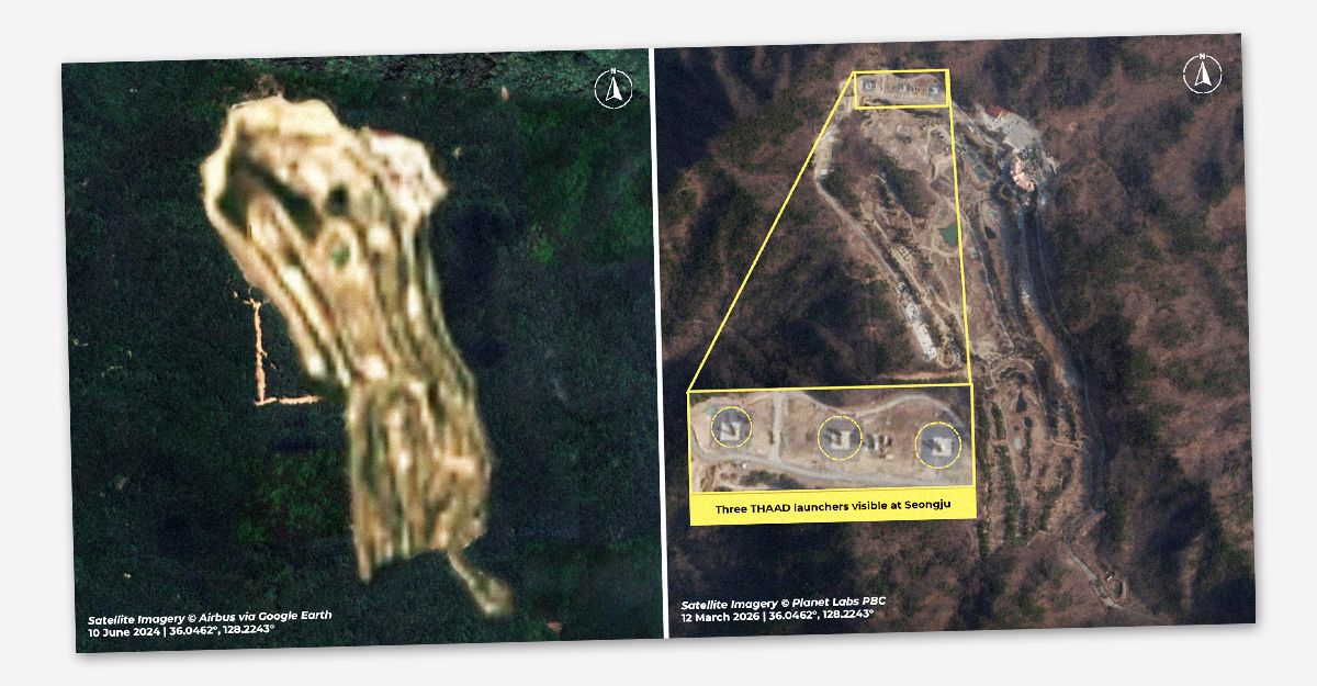
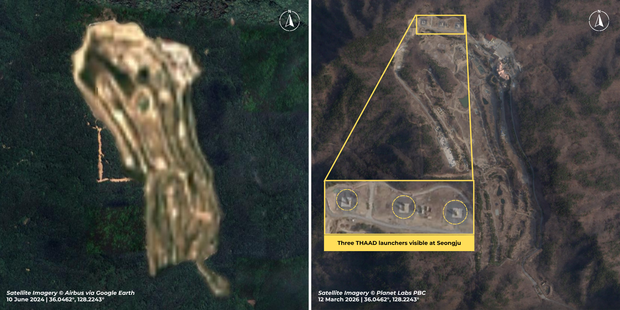
Google Earth recently began blurring out military sites in South Korea. Our team first discovered this development in early September when checking in on Lotte Skyhill Seongju Country Club, a golf course in South Korea where the United States has deployed a Terminal High Altitude Area Defense (THAAD) missile defense battery since 2017. Although the site was visible just a week prior, the entire golf course is now obscured.
The blurred effect appears in all of the historical imagery of the golf course available on Google Earth, as far back as 1985. A quick search revealed that other military bases in South Korea, such as Camp Humphreys, Osan Air Base, and the Chinhae Navy Base, have been blurred as well. Open-source analysts like our team, however, can easily get around this obscurement. Both Planet Labs and Vantor, American companies with their own constellations of satellites, have recent, high-resolution imagery available of the Seongju golf course and other military sites.
The blurring of the sites begs the question: why bother with the secrecy at all? The answer is likely the business of national security. For years, Google and South Korea have had an ongoing dispute about maps of the country. In 2016, South Korea denied Google’s request for access to high-resolution local maps developed by the South Korean government, which Google needed in order to provide in-country navigation directions via Google Maps. South Korea’s justification was that Google compromised the country’s national security due to their refusal to blur out sensitive sites on their products. Google’s stance at the time was that anyone can purchase access to the (non-blurred) satellite images that the company uses in its products. Yet in August 2026, following its most recent request for map access, Google capitulated, offering to blur South Korean sites. Soon after, South Korea’s Transport Ministry announced approval for Google to use their maps.
The changes to Google Earth and Google Maps have also had the perhaps unintended effect of hiding the U.S. military’s actions in the region and beyond. In March 2026, sources reported that after Iran damaged THAAD systems in Jordan and Saudi Arabia, the United States had begun to move parts of the system from South Korea to the Middle East, initially by relocating the system to Osan Air Base (in Pyongtaek City, South Korea). Little else was known about the movement. In April, U.S. Forces Korea Commander General Xavier Brunson contradicted these reports, stating to the Senate that no THAAD system had been moved. Sources later reported that the launch vehicles of the THAAD battery were returned from Osan back to Seongju, and only the vehicles’ interceptor missiles were left at the base for shipment to the Middle East. Google’s decision to censor South Korean military sites makes it difficult for journalists, analysts, watchdogs, and the public writ large to track and determine the truth of situations like this.
This is not the first time Google has agreed to censor imagery at the behest of governments. FAS has previously documented Google’s censorship of military sites in France and Belgium at the request of their respective governments. Even though national security is the oft-used justification for these decisions, real national security risks are not mitigated through free tools like Google Earth aimed for public use. Other countries have their own satellites with clear views of every military or relevant governmental site. As noted by FAS’s Matt Korda in 2018, blurring sites can induce the Streisand Effect, in which attempting to hide something can actually result in extra attention. Blurring is easily detectable on a satellite image, but we are quickly approaching an era of increased secrecy as the accuracy of satellite deepfake images improves.
Allowing obfuscation at this broad level poses a direct threat to the public’s ability to monitor and scrutinize government operations–a core function of the democratic process. Google’s decision appears to be a surface-level strategy in the name of business and national security that primarily hinders the public’s, not the adversaries’, access to information. Nor are all military facilities equally sensitive, a fact such broad restriction ignores. The effect seems more about restricting public access than securing military assets. The case illustrates how companies with significant interests in government data can be coerced into surrendering to excessive secrecy.
This is not the first time Google has agreed to censor imagery at the behest of governments, but be warned: obfuscation at this broad level poses a direct threat to the public’s ability to monitor and scrutinize government operations.
As humans expand our geographic reach, encroach on untouched natural territories, and interact more with animal populations, we will encounter novel zoonotic diseases that threaten the human body. The sooner we act to address these risks, the better.
“One thing became increasingly clear: AI doesn’t simply introduce a new category of risk. It changes the speed, scale, complexity, and interaction of risks that already exist.”
In the current environment of declining trust and magnifying strategic competition, banning debris-creating tests is a concrete step towards stability that favors interests of all states seeking to conduct space activities.