Google Introduces Deepfake Satellite Imagery: “It’s Fun!”
[Update: On July 31st, following significant backlash, Google announced that it was temporarily “rolling back” this feature “while we work on implementing stronger guardrails.”]
Google’s motto famously used to be “don’t be evil.” However, its latest feature has just made being evil a whole lot easier.
On July 30th, without much fanfare, Google Earth unveiled an experimental new feature: the ability to produce custom deepfake satellite imagery with its inexplicably-named “Nano Banana 2” image generation model. As the press release explains, “Just zoom in to a place in Google Earth […], tap ‘create image,’ and type whatever you want to see.”
The press release offers some colourful examples for what users can do with this new feature, including creating real estate plans, visualizing what a place might look like in 100 years, or bringing history to life by transforming the ruins of Pompeii into a pre-eruption metropolis.

A screenshot from Google’s 30 June 2026 press release demonstrating one use case of its new “create image” feature: visualizing pre-eruption Pompeii.
While many users will indeed probably use this feature for benign purposes, the press release fails to mention its obvious and inherent risks. If it only takes a minute to generate satellite imagery of a fake real estate plan, it takes the same amount of time to generate satellite imagery of a fake missile base on alert. Or a nuclear power plant melting down. Or an airport on fire. Or a bomb crater in a war zone. Or any other number of potentially panic-inducing images waiting for an opportunity to go viral. If the scene isn’t realistic enough, the tool features a “refine” button to make it more believable.
Google is bearish about the likelihood that its manipulated images will cause panic. In an X post responding to criticism of its new feature, it wrote that “every image created with Nano Banana in Google Earth includes the SynthID digital watermark, so if someone is unsure about an image, they can ask the Gemini app or use Lens in Search to see if the image was AI-generated.”
Not only did researchers quickly disprove this, but Google’s response unhelpfully shifts the onus of verifying complex instances of disinformation onto end users. A casual observer coming across a potentially manipulated satellite image is simply not going to go to the trouble of plugging that image into SynthID to check its digital watermark––particularly in an age when rapidly spreading outrageous claims is typically rewarded (often by the same technology companies that generate disinformation!) with financial and viral compensation.
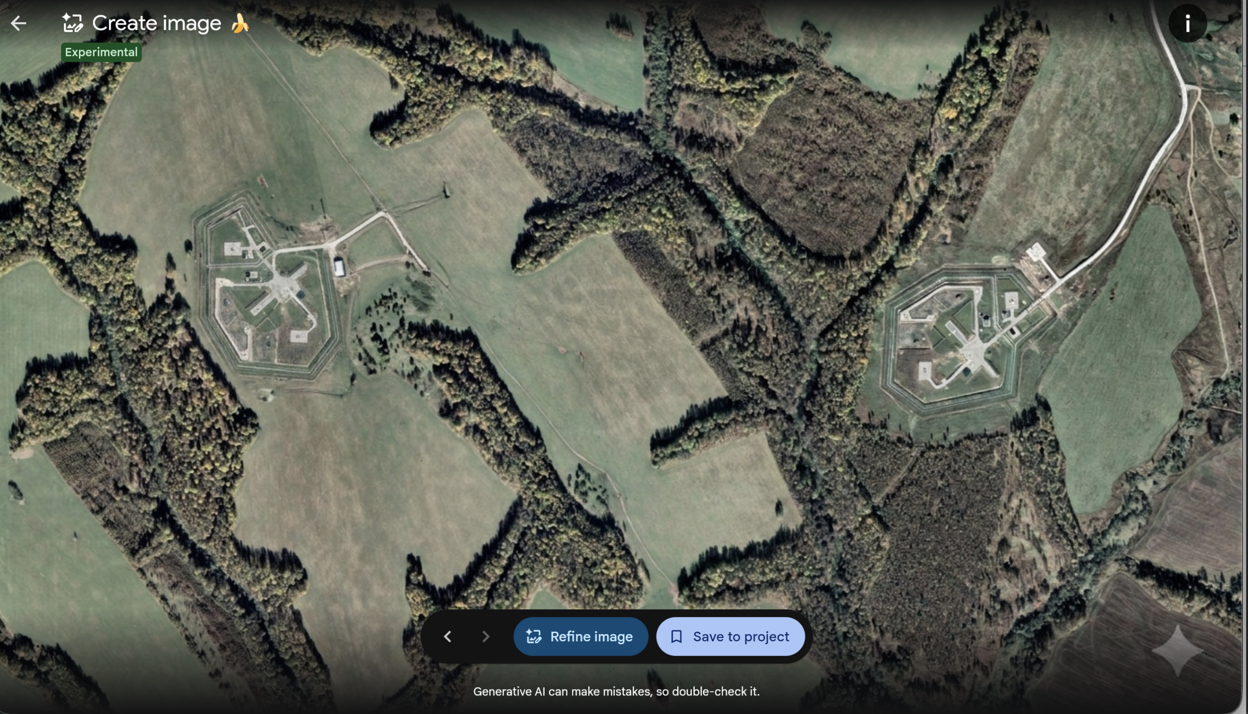
Google’s response also stated that “we prevent image creation on harmful topics.” Yet it’s clear that there are very few guardrails on this new feature. Within a few short hours, researchers generated fake bomb craters, nuclear power plants, mass protests, waves of refugees, fires, and other instances of humanitarian disasters. I created a fake Russian ICBM silo next to a real one; can you tell which one is which? As Google’s press release says: “Sometimes it’s fun to let your imagination run wild.”
An image of two Russian intercontinental ballistic missile silos––one real (right), one fake (left)––produced by the author using Google Earth’s new “create image” feature.
Being evil just got easier
Experts have been warning about the possibility of deepfake satellite imagery for years. Not because these images on their own are likely to start wars or influence targeting operations, but because they can easily generate mass panic, confusion, and rapidly sway public opinion. Features like this also serve to devalue and undermine the field of geospatial analysis writ large. One can easily imagine malicious actors using this for their own gain by generating images that propel their own narratives.
Is there overwhelming evidence that your military targeted a school instead of a missile base? Don’t worry, simply generate a competing satellite image showing that the flattened school actually housed some suspicious underground tunnels. Or better yet, generate one showing that the school is fine and was never destroyed in the first place.
Even the mere existence of such a feature allows anyone, from government officials to your uncle at Thanksgiving, to more easily claim “fake news” when presented with otherwise compelling evidence––or create “fake news” themselves. Truth is increasingly irrelevant in an age where media ecosystems intentionally amplify preconceived narratives, and bad-faith actors seeking to spread disinformation don’t care about getting caught.
Moreover, as AI-generated content is increasingly undermining our collective ability to differentiate between fact and fiction, it undermines trust in real analysis. If we accept that any satellite image could be a deepfake, one of the best tools that analysts have used for decades to challenge government narratives or inform the public will be severely degraded.
A new path to censorship?
Open-source researchers are increasingly encountering instances of government-initiated censorship on mapping platforms. For example, in 2018 I reported that Yandex had blurred out more than 300 military sites in Israel and Turkey. In 2026, NRK reported that they had begun doing the same for sites in Russia. We have documented several instances of Google blurring out military sites and prisons in France and Belgium, as well as an instance of a Dutch company selling FAS a doctored image of Volkel Air Base. And this past spring, Planet blocked the release of its satellite imagery over the Middle East in direct response to a request from the Trump administration.
For the most part, however, it is easy to tell when a site has been censored: it is typically blurred out or sloppily painted over. And not only do blurred sites draw attention to their importance, but it’s also relatively easy to find an unblurred image of the same site on a different platform, particularly if that platform is based in a different legal jurisdiction.
Google’s new feature, however, begs the question of whether we will increasingly see a different kind of obfuscation methodology––one that can be much more difficult to detect. Want to hide your country’s new missile silo? Rather than blurring it out and drawing attention to it, a country could simply ask satellite imagery companies or mapping platforms under its influence to adjust it until it no longer looks suspicious. While it won’t fool another country’s military intelligence, it could significantly degrade the abilities of open-source geospatial analysts, which overwhelmingly rely on public platforms like Google Earth as a source of truth. As tech researcher Henk Van Ess has noted, “the fake is made inside the thing people use to check whether pictures are true.”
In a world increasingly filled with AI slop, satellite imagery has been one of the bastions of ground truth because it is very difficult to manipulate it without making it look unrealistic, and Google Earth is the most accessible and universally used tool for analysts, activists, and journalists to understand what is happening in the world. It is somewhat baffling that Google is actively choosing to degrade its own product that it has spent decades perfecting, and given the overwhelming backlash following the release of this new tool, its development suggests a degree of negligence on the part of tech giants to understand their own responsibilities to limit disinformation.
[Update: On July 31st, following significant backlash, Google announced that it was temporarily “rolling back” this feature “while we work on implementing stronger guardrails.”]
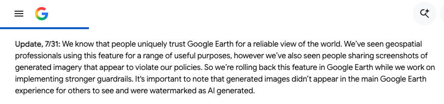
An update to Google’s original press release announcing the rollback of the “create image” feature.
The Nuclear Information Project is currently supported with generous contributions from the Andrew Carnegie Foundation, the New-Land Foundation, Ploughshares, the Prospect Hill Foundation, and individual donors.
Israel has deleted several military facilities from its official map by replacing them with fake farms, deserts, or paint splotches.
A Russian mapping service has selectively obscured political and military facilities in both Israel and Turkey, which has had the unintended effect of revealing their exact locations to the world.