Event: Conference on Using Satellite Imagery to Monitor Nuclear Forces and Proliferators
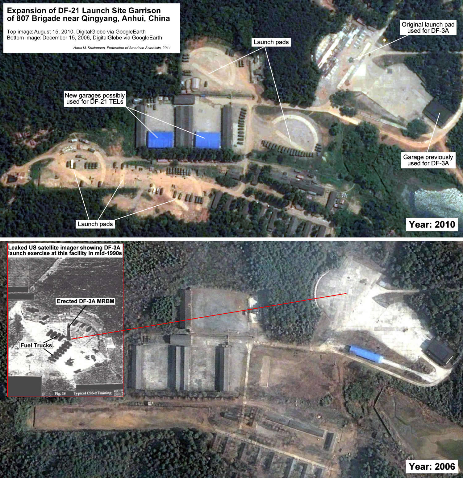 |
| This satellite imagery analysis from my conference briefing illustrates upgrade of Chinese mobile nuclear missile launch garrison at Qingyang (30°41’52.64″N, 117°53’36.25″E). Such analysis is becoming more important as the U.S. government is curtailing what it releases about Chinese (and Russian) nuclear forces. Click on image for large image version. |
.
By Hans M. Kristensen
Earlier today we convened an exciting conference on use of commercials satellite imagery and Geographic Information Systems (GIS) to monitor nuclear forces and proliferators around the world. I was fortunate to have two brilliant users of this technology with me on the panel:
- Tamara Patton, a Graduate Research Assistant at the James Martin Center for Nonproliferation Studies, who described her pioneering work to use freeware to creating 3D images of uranium enrichment facilities and plutonium production reactors in Pakistan and North Korea. Her briefing is available here.
- Matthew McKinzie, a Senior Scientists with the Natural Resources Defense Council’s Nuclear Program and Lands and Wildlife Program, who has spearheaded non-governmental use of GIS technology since commercial satellite imagery first became widely available. His presentation is available here.
- My presentation focused on using satellite imagery and Freedom of Information Act requests to monitor Chinese and Russian nuclear force developments, an effort that is becoming more important as the United States is decreasing its release of information about those countries. My briefing slides are here.
In all of the work profiled by these presentations, the analysts relied on the unique Google Earth and the generous contribution of high-resolution satellite imagery by DigitalGlobe and GeoEye.
This publication was made possible by a grant from Carnegie Corporation of New York and Ploughshares Fund. The statements made and views expressed are solely the responsibility of the author.
The United States’ biosecurity governance system is structurally incapable of detecting and responding to certain classes of threats. U.S. biosecurity tools have not kept pace with technological advancements or a changing threat landscape.
FAS and FLI partnered to build a series of convenings and reports across the intersections of artificial intelligence (AI) with biosecurity, cybersecurity, nuclear command and control, military integration, and frontier AI governance. This project brought together leaders across these areas and created a space that was rigorous, transpartisan, and solutions-oriented to approach how we should think about how AI is rapidly changing global risks.
AI is already consequential, but its future trajectory remains contested. Policymakers should make their assumptions explicit, focus on what can be shaped rather than what can be perfectly predicted, and build institutions that can learn and respond as evidence changes.
From grassroots community impacts to global geopolitical dynamics, understanding developing data center capacities is emerging as a critical analytical challenge.