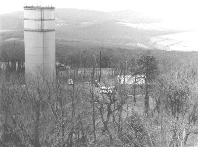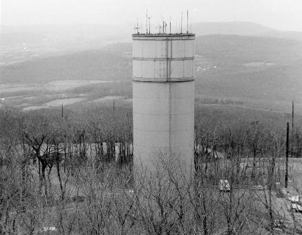
This facility, clearly visible above the trees from several major highways, is located on a mountain called Lambs Knoll. The USGS quad map for Keedysville, MD (39077-D6-TF-024) places the site between Middletown MD and Rohersville MD, on the spine of South Mountain (close to the Appalachian Trail). The closest public road is "Reno Monument Rd." and (as the name suggests) a monument to the Civil War commander Reno is located at the junction of Reno Monument Road and the unnamed service road to the site. The USGS map identifies a fire/lookout tower, a USGS benchmark, and a helipad. The online Tiger Map server puts the lat/lon at: Lat: 39.4483604 Lon: -77.6271667)
The facility is fenced, with an unmanned electric gate. No signage whatsoever. The access road (marked Private) is well-maintained single-lane blacktop that is classically snow-free in the winter. The service road proceeds through the gate and circles around to the base of the silo where it terminates at metal door below ground level (a sort of garage door that's set about "basement" level). There are no other above ground structures visible within the grounds. People do work there, and typically wear blue, unmarked jumpsuits or coveralls.It is clear that there had been considerable earthmoving at the time of construction. On the opposite side of the service road was a substantial 'spoils pile' of dirt and rock that appeared to come from the excavation (similar to the Raven Rock site). The base of the silo rested on a dead flat rectilinear area about a few hundred feet square. Also within the fenced area are a couple of collapsible antenna masts with arrays similar to MARS antenna seen on military bases (medium-band communications -nothing fancy).
AT&T relay tower and an unused fire tower are nearby. Outside of the perimeter fence, and a few hundred yards down the slope of the hill is another interesting artifact. About 100 feet off of the service road (well into the woods) is a ground-level concrete pad about 6 x 6 feet. It is covered by a low wooden rooflike structure set directly upon the concrete. The whole assembly is only about 12 inches high. Underneath this (it is held in place only by its own weight), are a pair of green steel "cellar doors" set flush with the concrete pad. Opening these doors yields a recess in the pad about 6 to 8 inches deep with a circular hatch set centrally. It is similar to pressure doors that you might see on a submarine or similar watertight application.The locals refer to this thing as "the missile silo" though no one has ever discovered exactly what it is. One local Maryland State Police officer called it "the missile site." Other local opinions/theories have called the facility a weather station, an atmospheric test facility, and a radar site. An Army Colonel is reported to have claimed that the site had been used as part of the defensive ring around DC and had been a missile site of some sort.