SYNOPSIS: PLRS PROVIDES TIMELY AND ACCURATE THREE DIMENSIONAL POSITIONING, LOCATION, AND REPORTING INFORMATION IN SUPPORT OF TACTICAL COMMANDERS.
ACQUISITION CATEGORY III
ACQUISITION PHASE: Fielded
PE & LINE #:
DESCRIPTION: The PLRS is a Command and Control aide that provides automatic, real-time position reporting in a division's area of responsibility. During the Gulf War, coalition forces moved vast distances over featureless terrain at incredible speeds to defeat the armies of Iraq. This effort required the careful orchestration of men, machines, and supplies. Had the tanks and armored personnel carriers gotten too far ahead of the supply train, or gotten lost, they might have run out of fuel in enemy territory and been at great risk. Units of troops might have become separated and subject to attack by hostile or friendly forces. Without certain knowledge of friendly unit locations, attack forces would have been faced with the difficult task of first identifying hostile units prior to attack. The task of locating the troops, tanks, airplanes, and supplies under such conditions would have been impossible without the help of the Position Locating Reporting System (PLRS).
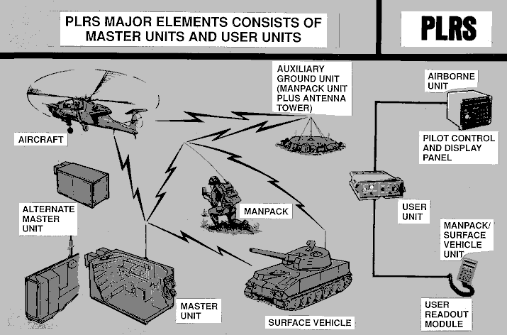
The system employs a Master Station and an Alternate Master Station for 100% backup to insure system survivability and continuity of operations during displacements. The Air Transportable Master Station provides computer controlled network management and continuously updates the position of deployed User Units in manpack, vehicle and airborne configurations. PLRS direct support maintenance will be aided through the use of special TMDE - the PLRS Test Set. PLRS equipped units can obtain their own position, range and bearing relative to other units or locations. PLRS equipped units also can establish aircraft corridor guidance and provide an alarm when entering a pre-designated restricted area such as a minefield, and provides a free format abbreviated data message from other users. The system is crypto-secure and is highly resistant to jamming. The network, under Master Station management automatically utilizes surface airborne User Units as integral relays to achieve over-the-horizon transmission and to overcome close-in terrain obstructions to line-of-site communications.
PLRS has a highly jam-resistant network of synchronous UHF radio transceivers, automatically exchanging short duration pre-formatted data messages, that enables the position of all units in the net to be determined rapidly. By reference to an absolute grid system - Military Grid Reference (MGR) - PLRS has navigational capabilities in addition to the position location feature. PLRS produces positions accurate to within 15 meters. Use of PLRS allows commanders to plot and know that troops will be within safe areas and corridors, plot minefields, direct air and artillery strikes, and a host of other position sensitive tasks with confidence.
The Manpack Unit, AN/PSQ-4, weighs 23 pounds, includes a Basic User Unit, User Readout (URO), two batteries and a battery case. The Manpack Unit is used at the platoon level. The User Readout may be replaced with a ruggedized Portable Computer (PC), thus allowing the manpack unit to become a mini Command and Control station. The PC allows a local area map along with position and ID information, from the PLRS Master Station, to be displayed. This information may be used by tactical commanders for maneuver control, fire control, localized air defense, or for control of amphibious operations. For use in vehicles, the Manpack Unit is mounted in a tray, with power provided by the vehicle. For this type of installation the URO and an antenna are mounted directly to the vehicle. For use in aircraft, the Manpack Unit is mounted in a frame, and the URO is replaced with a Pilot Control Display Panel (PCDP). Bearing data from the PCDP can be displayed on the cockpit Bearing Direction Indicator via the synchro bearing output.
PLRS began as a USMC program back in the early `70's, becoming a joint USMC/U.S. Army program in 1976, as an attempt to provide warfare commanders with a real-time, electronic picture of the battle environment. The PLRS concept envisioned a system that would; provide positioning information to tactical commanders, provide navigational assistance to friendly forces, coordinate fire and air support, and assist control and maneuver of ground and air elements.
The initial PLRS system which was built by Hughes Ground Systems Group, consisted of a Master Station, a manpack for the infantry, and user units for aircraft and vehicles. The Master Station was a single S-280 militarized shelter, capable of being transported on a 5-ton truck. The data processing in the Master Station was provided by a single bay Unisys AN/UYK-7, and two Unisys AN/UYK-20 computers. The full sized, or upsized USMC version went into production in 1983.
HISTORICAL BACKGROUND: PLRS is a USMC program managed by PM, TRCS.
Aug 76-Aug 80 Full Scale Development Contract.
Jul 82 ASARC-III, Marine Corps approved PLRS for production.
Jul 83-Jul 86 Multi-year production contract award to HAC.
Sep 87 First Unit Equipped.
May 90 PLRS Follow-On Buy for USMC and Navy awarded.
May 92 PLRS/EPLRS Control Station Downsize Contract Award to Unisys Corporation.
Mar 94 PLRS Navy Buy and PCE Phase 2A Awards.
REQUIREMENTS DOCUMENT: Joint Service Operational Requirement (JSOR) approved 1976; JSOR update May 83. USMC Required Operational Capability (ROC) for PLRS improvement program, 11 Jan 91.
TYPE CLASSIFICATION: Standard A as of 1 Sep 82 ASARC-III. To date 98% of NSNs have been received. All development line items numbers (ZLIN) have been converted to standard line item numbers.
EVENT SCHEDULE FISCAL YEAR
96
97
98
99
00
01
QTR
1 2 3 4
1 2 3 4
1 2 3 4
1 2 3 4
1 2 3 4
1 2 3 4
GPSIU Production Award
4