 e-Printse-Prints
Counterspace Operations for Information Dominance
by
James G. Lee
INTRODUCTION
The Problem
The launch of the Soviet "Sputnik" satellite in October 1957 shocked the world and propelled the rhetoric and the realities of the Cold War into the space age. At the same time, the Soviet feat raised the threat of mass destruction from space, and served as the basis for strategists to argue for a means to shoot down enemy satellites. Although the arguments used to justify the need for an antisatellite (ASAT) weapon have changed in the years since "Sputnik," the policy and strategy for its employment have always focused on the need to destroy, or threaten to destroy, Soviet satellites on orbit.
The Need for a Change
Since the mid-1960's, US military strategy has focused on deterrence based on flexible response. US deterrent power is based on a balanced mix of nuclear and conventional forces, augmented by strong alliances, forward basing, and power projection. Likewise, US military space systems were initially developed in a Cold War context and viewed as primarily strategic systems--supporting the Strategic Air Command, the intelligence community, and the national command authorities. Timely, accurate, and unambiguous strategic and tactical warning information from reconnaissance, surveillance, and communication satellites provided situational awareness of our perceived enemy and became integral to the deterrent power of the triad.
In essence US military space systems became a defacto hidden leg of the strategic nuclear triad. The stability of US and Soviet nuclear deterrence rested on the ability of space systems to collect, process, and disseminate information. The balance of information provided by space systems resulted in each side having a sufficient degree of timely warning of the other side's actions. Maintaining the balance in warning information prevented one side from achieving surprise and rendering the other side incapable of a nuclear retaliatory strike. In fact, the value of the information from space systems was viewed as essential for Cold War stability, and many argued that space must remain a sanctuary to preserve stability. It was this position subscribed to by General Charles Gabriel, AF Chief of Staff, when he argued that the value of an ASAT weapon was not as an offensive device intended for creating an imbalance by conducting a first strike attack against the Soviet satellite system, but rather as a weapon deployed to deter attacks on our space systems. If deterrence of Soviet attacks upon our space systems failed, the ASAT was to be employed to restore the balance of information by counter-attacking Soviet satellites.
The most recent, and perhaps the most compelling, argument for an ASAT was articulated in 1987 by General John Piotrowski while serving as Commander in Chief, United States Space Command. General Piotrowski argued that, while space systems remain integral to the deterrent power of our nuclear triad, space systems have also become critical to the successful conduct of conventional war. General Piotrowski believed the ability to negate enemy satellites would enhance the warfighting capabilities of our terrestrial forces. Therefore, he concluded the true value of an ASAT rested with its contribution to deterring conventional war with the Soviet Union, and if deterrence failed, its ability to deny the Soviets use of their critical space systems. Piotrowski’s Cold War argument for an ASAT suggests that a counterspace capability may also be needed in an evolving world to increase deterrence of conventional conflicts, and if deterrence fails, to deny information to the enemy.
The Cold War appears to be over, but the world is, in many ways, much more complex. Gone is the relatively simple arrangement of bipolar alliances and loyalties that have characterized the four decades since World War II ended. In one sense the Cold War made the US national security strategy and foreign policy straightforward; to a large degree nations were considered either pro-Soviet or anti-Soviet. Today, the traditional and historical ethnic and religious animosities, once held in check by the fear of a common enemy, have re-emerged and, in some cases, erupted in civil war. The world we face in the future may likely be characterized by an increase in regional political instabilities, economic and social dislocation, and a widespread diffusion of conventional military power, coupled with the proliferation of the capability to create and deliver chemical, biological, or nuclear devices.
The thawing of the Cold War has also brought changes in our own military force structure. The dismantlement of the Warsaw Pact and the Soviet Union has left our political leadership with the perception of a reduced external national security threat. This perception, coupled with what seems to be an out of control US national debt, has resulted in a willingness to reduce US strategic and conventional military forces and their forward-based presence overseas significantly.
Although US forward presence is shrinking, the US will remain committed to NATO and the collective defense of other nations, such as Japan, Korea, and some of the nations of Southwest Asia. In order to project power rapidly and respond effectively to crisis situations worldwide, US conventional forces are becoming lighter, more rapidly deployable, and more expeditionary.
In the future the US may not have the same opportunity for extended mobilization in preparation for war, as was afforded in Operation Desert Shield. Regional crises and conflicts will probably be "come as you are," and the necessity to collect, process, and disseminate strategic and tactical information on the enemy's forces and terrain may become increasingly important to expeditionary forces which must fight effectively in potentially unfamiliar terrain against an unfamiliar enemy. Likewise, allowing an enemy access to information on US force deployments, order of battle, movements, and logistics, could jeopardize our ability to stage and deploy forces, and successfully execute our military strategy. Therefore, it would seem that the ability to control information may become increasingly important, and possibly decisive, in future military operations.
Since the ability to collect, process, and disseminate information to field commanders may become a decisive contributor to victory in future conflicts, information warfare actions may emerge as an essential function in crisis response and war. At the operational level, information warfare denies the enemy the capability to collect, process, and disseminate information with the objective of creating a positive information gap between friendly and enemy forces. This positive information gap has been referred to as information dominance.
Information Dominance
The concept of information dominance first emerged in the writings of Soviet military theorists in the late 1970's as part of a discussion of the concept of Military Technical Revolutions. The Soviets coined the phrase, military technical revolution, to describe past and future eras in which extreme transformations in warfare occurred as a result of the exploitation of technology. The Soviets, however, did not see technology in and of itself defining the revolution as the phrase might suggest. Rather, they saw the operational and organizational innovations resulting from the exploitation of the technology as defining a military technical revolution.
The Soviets predicted that the technological advances occurring in US information collection, processing, and dissemination, coupled with the increasing range and accuracy of precision guided munitions, would lead to the next military technical revolution. They believed, if fully exploited, these technologies could become the basis for logically integrated, yet geographically distributed weapon systems whose elements perform reconnaissance, surveillance, target acquisition, and target engagement. The increased emphasis of modern weapon systems on the reliance and the ability to collect, process, and disseminate information seems to suggest that the ability to establish information dominance over an adversary could be increasingly important to the conduct of military operations.
Information dominance can be described as a condition in which a nation possesses a greater understanding of the strengths, weaknesses, interdependencies, and centers of gravity of an adversary's military, political, social, and economic infrastructure than the enemy has on friendly sources of national power. Attaining information dominance could mean the difference between success and failure of diplomatic initiatives, successful crises resolution or war, or forfeiture of the element of surprise to the enemy in military operations. Therefore, the ability to attain information dominance can widen the gap between friendly actions and enemy reactions, and allow friendly commanders to manage the enemy's decision cycle by controlling and manipulating the information available to them. On the other hand, failure to achieve information dominance at the onset of hostilities could lead to the inability of friendly forces to conduct military operations successfully.
Today more than ever, information is power; consequently, military operations to attain information dominance should probably be initiated at the onset of a crisis to facilitate rapid mobilization and power projection, and sustained through the crises and, if necessary, through war. Information dominance can be obtained by conducting offensive and/or defensive military operations. Offensively, information dominance can be attained by collapsing an adversary's command and control infrastructure through offensive operations, such as the disruption of critical communication links; or by denying access to reconnaissance and surveillance information, such as blinding optical sensors with ground-based lasers. Defensively, measures such as hardening, frequency hopping, and encryption further ensure information dominance by helping to insure friendly forces have uninhibited access to communications, surveillance and reconnaissance information provided by space systems. Therefore, delaying and denying a potential adversary information, while providing similar information to friendly forces, can indeed be a valuable mechanism for balancing power during peacetime and a decisive terrestrial force enhancer/multiplier during war.
Role of Space Systems
Just as there is a synergism between air, land, and sea forces, there appears to be an emerging synergism between space systems and terrestrial forces, suggesting that space systems are becoming inseparable to land, sea, and air warfare. Existing military space systems have demonstrated an ability to provide near real-time command and control, weather, surveillance and reconnaissance, and navigation information to air, land, and naval forces. In Operation Desert Storm, for example, US Air Force space systems provided near-real-time surveillance data of Iraqi SCUD missile launches directly to the CENTCOM command center in Saudi Arabia. This warning data was then used to alert coalition forces and direct Patriot air defence artillery fire against the SCUD missile and direct air strikes in counter battery operations against the SCUD launchers. The integration of information from space systems with modern weapon delivery systems and precision munitions during Desert Storm would seem to validate the Soviet vision of the next military technical revolution and the importance of space systems to the concept of information dominance.
As space systems become more valuable to attaining national security and to our ability to support allies and promote international stability, their value to information dominance increases as well. Given the increasing importance of information from space systems to terrestrial military operations, attaining information dominance appears to require the capability to conduct counterspace operations.
However, the ability of the US to conduct counterspace operations may become increasingly difficult as space systems and technologies proliferate among nations. Indeed, the majority of the world space programs and systems, are considered civilian systems and were not initially developed or intended for dedicated military purposes. It may be prudent to assume that nations subsidizing civilian space activities are also exploiting these "non-military" satellites for military and national security information. For example, the French commercial space system SPOT has demonstrated an intelligence capability by providing commercial photographs of Soviet laser facilities at Sary Shagan. The inherent military capabilities of civilian space systems suggests the proliferation of space systems and technologies could have serious military implications with respect to our ability to establish information dominance.
In the past, the US and Russia could exercise a degree of control and leverage over the information other nations received from space systems through our collective monopoly on the ability to build and launch satellites. However, France, Japan, China, India, and Israel have all launched and orbited civilian satellites with imaging capabilities. Furthermore, nations such as Brazil, Canada, and Great Britain are also developing satellite systems capable of providing imagery with potential military utility. Indeed, nations do not even need to own space systems to have access to information from space. Numerous space faring nations, such as France, Russia, and Japan off-set the cost of developing and deploying space systems by marketing their information. In light of the increasing global instabilities and uncertainties, some nations may find it advantageous to make militarily useful information from civilian satellites available to countries hostile to the US; Brazil to Libya or China to Iran, for example. It is not unreasonable to speculate that in the future the US could find itself in a crisis situation, or war, with an adversary either operating their own space system, or relying on information from a another nation's space system. In this situation the US is usually portrayed as having only two options: do nothing, or destroy the enemy's satellite with an ASAT. Under international law it is generally accepted that the destruction of a nation's space system as an act of self defense is justified. However, in situations where the enemy is acquiring information from a space system owned by a neutral third party, the unilateral destruction of that satellite with an ASAT is considered an act of aggression and a violation of that nation's sovereignty. This suggests that there may be situations in which employing an ASAT to destroy a satellite may simply not be an acceptable alternative.
The apparent trend for global proliferation of space systems and marketing of space information seems to raise doubts regarding the flexibility and responsiveness of our current space control strategy and our ability to achieve information dominance. This thesis evaluates our current space control strategy in terms of our ability to ensure information dominance in the evolving national security environment characterized by the increasing proliferation of space systems. A discussion of the phenomenon of global proliferation of space systems and the military utility of civilian imagery systems is the focus of the next section. The section immediately following it entails an assessement of our current space control strategy and policy with respect to the emerging threat from proliferated space capabilities. The last two sections offer both an alternative space control strategy to deny the enemy the use of information from space systems and a means to implement that alternative space control strategy.
PROLIFERATING SPACE TECHNOLOGY
Nations possessing space capabilities can be divided into three tiers: First tier space capable nations possess dedicated military and civilian space capabilities on the cutting edge of technology; second tier nations develop and use dual-purpose space systems for both military and civilian purposes; and third tier nations lease or purchase space capabilities or products for military and civilian purposes from first and second tier nations. Table 1 gives examples of nations in each of the three tiers.
Proliferation of Civilian Space Capabilities
Nations within the first tier, the United States and Russia, have disseminated surveillance and reconnaissance products from dedicated military satellite systems to alliance partners for many years. There are also several civilian corporations selling space products, such as communication channels, weather information, and Earth imagery, on the international market to most any nation able to pay the price. In fact, one of the major sources of Earth imagery available on the commercial market is from the US civilian satellite system, Landsat.
|
Tier |
Country |
|
First |
United States Russia |
|
Second |
France |
|
Third* |
Brazil Italy |
*
Not all inclusive, only major nations in this category are listedTable 1: Space Capable Nations by Tier Group
Landsat is an Earth remote sensing satellite system. There are currently two operational Landsat satellites each capable of providing imagery in seven spectral (color) bands, and one black and white panchromatic band. The most recent Landsat launched, Landsat 6 in 1992, is capable of producing black and white images with a ground resolution of 15 meters.
Initially owned and operated by the National Oceanic and Atmospheric Administration (NOAA), the Landsat system was privatized in 1979 and is now operated by a private company, EOSAT, for NOAA. Under the provisions of the Remote Sensing Act, Landsat data must be made available for sale to any individual or nation on a nondiscriminatory basis. The Secretary of Defense, however, does have the authority to determine customers or circumstances for which the sale of Landsat data can be denied for national security reasons. Presently, the Department of Defense has not established any criteria or specific provisions for restricting the sale and distribution of Landsat imagery.
In addition to selling processed Landsat imagery products, NOAA/EOSAT also oversees the establishment and licensing of Landsat ground stations in foreign countries. In addition to the Landsat ground station in the United States, there are currently 13 licensed stations with plans to build another two outside the United states. These Landsat ground stations can receive and process Landsat data directly from the satellites. Table 2 shows the locations of current and projected licensed Landsat ground stations.
|
Existing |
Projected |
|
United States Brazil |
Ecuador New Zealand |
Table 2: Existing and Projected Landsat Ground Stations
The technology and facilities required to build and operate a Landsat ground station are simple and relatively cheap when compared to the cost of developing, launching, and operating a comparable satellite system. Costs to construct a Landsat ground station are about $20 million, plus an additional $3 million a year in operational costs. The NOAA/EOSAT licensing fee is a flat $600 thousand a year. Once licensed, ground stations are permitted to receive, process, and sell Landsat information in accordance with the US policy on nondiscrimination.
Although the technology and equipment to build and operate a Landsat ground station is straightforward and inexpensive, it is also subject to US export controls. The US government uses export controls and its final approval authority for foreign ground station construction as a means to control the proliferation of space technology.
Consequently, no member of the former Soviet bloc has yet received approval to establish a Landsat ground station. Controlling the information from Landsat is, however, a different matter. Presently, the only way to restrict the foreign ground stations from directly receiving and processing downlinked Landsat data would be for EOSAT, to command the satellite sensor not to image the area in which data is to be denied. Commanding the sensor "off," however, would also deny imagery data from the specific area to other licensed ground stations and the United States because the current Landsat satellites have no on board data storage capability. In addition, since most foreign ground stations do not have the capability to command the Landsat controlling unauthorized direct access to Landsat data appears fairly reliable.
Russia, the other first tier space nation, also sells photographic imagery of the Earth's surface from satellites. This information, however, is derived from their KFA 1000 camera carried onboard the Resurs series military satellites. In 1987 the Russians began to sell, through the Soyuzkharta company, black and white photographic images with five-meter ground resolution of any site/area located in non-socialist countries. Even though the Russians seem to be in need of hard currency and concerned with the survival of their space program, they have not yet licensed, nor do they appear interested in commercially licensing foreign satellite ground stations.
The Resurs satellite represents older technology and uses a recoverable film canister from the satellite to produce earth imagery rather than the processing of downlinked digital imagery data like Landsat. Although technologically obsolete compared to the Landsat, the five-meter ground resolution of Resurs imagery is currently the best available on the commercial market.
Second tier space nations are growing in both numbers and capability. France was the first nation to challenge American and Russian dominance in space with its commercial space launcher, Ariane, and is now a third major competitor in the commercial remote sensing market.
The French Satellite Probatoire d'Observation de la Terre (SPOT) can provide multispectral remote sensing data in four spectral bands with ground resolutions of 10 meters in black and white panchromatic imagery, and 20 meter resolution for imagery in other spectral bands. SPOT Imaging Corporation describes the current capabilities of its satellite as having sufficient resolution to allow detection of objects 10-30 meters in size, recognition of objects 20 to 60 meters in size, and description of objects 60 or larger. In addition, the imaging sensor onboard SPOT satellites has the ability to look 27 degrees to the right or left of the satellite track. This off-nadir imaging capability allows the same area of the earth to be imaged on successive orbits from different viewing angles. Fusing multiple images of the same area from different viewing angles results in a capability to produce stereo images.
Imagery data from SPOT satellites can be transmitted directly to ground stations, or archived on tape recorders onboard the satellite for later transmission. Regardless of the source, all imagery data is downlinked to either the SPOT primary control center near Toulouse, France, or the SPOT control center near Kiruna, Sweden. These two ground stations are primarily responsible for processing the imagery data stored on the onboard tape recorders and data collected over the north polar region, Europe, and North Africa.
SPOT Image has also established a global network of receiving stations to receive, process, and disseminate satellite imagery on a similar nonÄdiscriminatory basis as NOAA/EOSAT for the Landsat system. Table 3 shows the location of current and planned SPOT ground stations worldwide. French export controls governing the transfer of technology to establish and operate a SPOT ground station are similar to those employed by the United States. SPOT, however, also restricts the area in which each ground station is authorized to receive and process data. India for example, is authorized to receive imagery data directly from the SPOT satellite only while the satellite is within a 2,500 Km radius of the Indian ground station. Thus the Indian ground station can only receive and process images of its own territory even though it is capable of receiving and processing data encompassing a much greater area. SPOT accomplishes these restrictions by withholding certain bits of information regarding the satellites mode of operation and orbit needed to process data from the satellite.
Through a combination of the receiving restrictions and the onboard tape recorders, SPOT was able to deny images of the Persian Gulf region during operations Desert Shield and Desert Storm to Iraq while providing it to the Coalition forces. SPOT does, however, acknowledge that a ground station could break out the information needed to circumvent the restrictions and gain access to the data from unauthorized zones. Although this ground station would not be able to sell these images overtly, it could provide them to the host country's government for intelligence purposes or sell then clandestinely.
|
Existing |
Projected |
|
|
France |
Ecuador China South Africa Taiwan Indonesia Sadi Arabia |
|
Table 3: Existing and Projected SPOT Ground Stations
In addition to its civilian space systems, France is also expanding its space program into the military arena by spinning off the civilian SPOT satellite technology to develop a dedicated military reconnaissance satellite called Helios. Helios, a joint development project with Italy and Spain, is reported to have ground resolutions approaching 0.3 meters using both multispectral imagery and a synthetic aperture radar. Although Helios imagery will most likely not be available for purchase on the commercial market, the similarities between SPOT and Helios technology could result in significant improvements for the SPOT system.
Peter Zimmerman, a physicist at the Carnegie Endowment for International Peace, speculates that with minor improvements in optics SPOT imagery resolution could be improved to 2.5 meters. In fact, the next generation SPOT satellite, SPOT 5, is reported to be capable of providing earth imagery at resolutions less than 5 meters. Richard Del Bello of the Office of Technology assessment believes the blurring of military and civilian technology will result in one-meter ground resolution becoming a commercial imagery standard by the year 2000. This seems entirely likely and achievable considering the projected resolution capabilities of SPOT 5 and its expected competition with the Russians who are already beginning to market imagery with a 2.5-meter resolution.
Some other second tier space nations include: China, Israel, Japan, and India. China, in addition to operating a licensed Landsat ground station, launched its first photo intelligence satellite in 1975 and has since orbited at least twelve imaging satellites. The Chinese FSW-1 series imaging satellites use a recoverable film canister retrieval method for returning images to Earth after an average mission duration of two weeks. The imaging products derived from the FSW-1 satellites are believed to be capable of less than 80-meter resolution and clearly support civilian earth resources and military reconnaissance activities. China is also engaged in a joint program with Brazil to produce and launch the China/Brazil Earth Remote Sensing satellite (CBERS). Projected for a late 1993 launch, CBERS will provide multispectral imagery, similar to SPOT and Landsat, with a expected ground resolution down to 20 meters. In addition to developing a remote sensing capability, the Chinese also have an expanding launch capability with the Long March series of boosters. The most recent Chinese booster, Long March 2E, is considered a heavy lift vehicle with performance between the US Atlas II and Titan IV boosters. The Long March 2E is capable of boosting 9200 kg into low earth orbit or 3370 kg into a geosynchronous transfer orbit.
Another second tier space nation, Israel, started its space program in 1988 as a response to Israeli discontent with having to rely on the US to provide satellite imagery. Several high ranking Israeli cabinet officials suspected that the United States withheld satellite imagery prior to the 1973 Yom Kippur war. Therefore, with the assistance of South Africa, Israel built and launched OFFEQ-1 in 1988, and OFFEQ-2 in 1990. Although the Israelis deny the OFFEQ satellites carry a photo-reconnaissance payload, the nature of the orbit, 200 km at the lowest point and 1500 km at the apogee, is a good indication that they have some intelligence gathering utility.
Japan is another second tier space nation with a rapidly developing civilian space capability. The Japanese Earth Remote Sensing Satellite (JERSÄ1), launched in 1992, possesses seven spectral bands capable of producing images with 18 meter ground resolution and a synthetic aperture radar capable of 25 meter ground resolution. Data from the JERS-1 satellite is not available commercially, although Japan's National Space Development Agency (NASDA) may authorize sales of data in the future.
Japan is also actively developing a commercial space launch capability. NASDA has been pursuing a space launch program since 1969; however, in exchange for US rocket technology, Japan agreed to launch only Japanese payloads. NASDA's newest space launcher, the H-II, is entirely a Japanese design and will allow Japan to enter the commercial launch market. Scheduled for an initial launch in 1993, the H-II is reported to have the ability to place 9,080 kg into low earth orbit and 3,600 kg into a geosynchronous transfer orbit.
India is another nation actively pursuing self sufficiency in space. The Indian Resources Satellite series (IRS 1A - 1988, 1B - 1991, and 1C - projected for a 1993 launch) has two sets of imaging sensors with ground resolutions of 72 meters and 36 meters respectively. The next generation of Indian remote sensing satellites is projected to have improved sensors giving it a multispectral resolution of 20 meters and a panchromatic imaging resolution of 10 meters.
Third tier space nations such as Pakistan, Indonesia, and Luxembourg have chosen, for political or economic reasons, not to develop or operate their own satellites. Tier-three nations acquire space information products through direct purchase or through licensing agreements to build ground stations. Although these nations are dependent on foreign sources for their space needs, this dependence is mitigated to some degree by building their own ground stations and obtaining licensing agreements to receive and process foreign satellite data, as in the case of Landsat and SPOT.
Military Utility
As increasing sophistication of civilian space technology blurs the distinction between military and civilian space capabilities, the probability civilian satellites will be used for military and national security purposes also increases. SPOT Image Corporation, for example, openly advertises the intelligence gathering and military utility of SPOT imagery. Marketed as "The New Way To Win!" SPOT illustrates the potential for nations to exploit the inherent military capabilities of civilian systems for military and national security purposes. As the number of nations developing their own satellites, or establishing satellite ground stations to process satellite imagery increase, the proliferation and exploitation of civilian imagery data for military purposes could impact the ability of the United States to prepare for and conduct military operations.
Assessing the military utility of civilian systems requires an understanding of some of the qualitative measures used to evaluate the capabilities and utility of remote sensing/imaging satellites. Spatial resolution, spectral resolution, and revisit time are the most common attributes used to compare and assess the capabilities of imaging satellites. Table 4 shows the spatial and spectral resolution and the revisit frequency of several civilian imaging/remote sensing satellites with commercially available products.,
|
Country (system) |
Resolution (meters) |
Spectral Channels |
Revisit Cycles (days) |
|
France (SPOT) |
10-20 |
4 |
2.5 |
|
Japan (JERS-1) |
25 |
7 |
44 |
|
Russia* (Resurs/KFA 1000 camera) |
5 |
2 |
14 |
|
USA (Landsat 6) |
15 |
8 |
16 |
*
The Russian Resurs satellite was initially developed for military purposes, however imagery is now marketed for commercial purposes.Table 4: Qualitative Measures of Various Civilian Satellite Systems
Spatial resolution refers to the size of an object on the ground a sensor can distinguish. For optical sensors, spatial resolution is typically the area on the ground that is observable by a single light sensitive sensor element, or pixel. A pixel for an infrared sensor, for example, is a single infrared cell. The area observable by the single sensor pixel is called a sensor's instantaneous field of view (IFOV). A sensor cannot detect any object on the ground smaller than its IFOV. Normally it takes at least two pixels to distinguish what a detected object actually is. Therefore, although a satellite with a 10-meter IFOV can detect a 10-meter object on the ground, under normal circumstances it can only distinguish objects 20 meters or larger in size.
For military purposes spatial resolution characterizes the satellite's ability to perform the delineation tasks such as: detection, general identification, precise identification, description, and technical analysis. Detection refers to locating a class of objects or an activity, such as a naval vessel or a rail switching yard. General identification is the ability to determine a general target group, while precise identification is the ability to discriminate within a target group. General identification of missiles, for example, would distinguish between ballistic missiles and surface to air missiles. Precise identification of missiles, on the other hand would distinguish between Hawk or Patriot surface-to-air missiles. Description refers to determining the size/dimension, configuration/layout, component construction, or equipment count of the target group, such as the difference between an F-15E on an F-15C. Technical analysis is the detailed analysis of specific equipment within the target group. Imagery supporting technical analysis allows the capability or limitations of a piece of equipment to be evaluated. Table 5 shows the ground resolution needed to perform the various delineation tasks for various objects of interest to military planners.
Historically, analysts generally believed that to be useful for military purposes, imagery and remote sensing satellites would need ground resolutions less than 10 meters. Typically satellites with ground resolutions greater than twenty meters were not considered militarily significant, being viewed as useful primarily for only terrain analysis and economic purposes. There is, however, growing evidence that satellites with ground resolutions between 10 and 20 meters, such as Landsat and SPOT, can have significant military utility. The United States Defense Mapping Agency, for example, is one of the largest users of SPOT and Landsat imagery. Commercial imagery from Landsat and SPOT have been instrumental in the generation of three dimensional targeting information for cruise missiles and other precision guided munitions.
All entries in meters.
|
Target a |
Detection b |
General ID c |
Precise ID d |
Decsription e |
Technical Analysis f |
|
|
Bridges |
6.0 |
4.5 |
1.5 |
1.0 |
0.3 |
|
|
Comm: Radar |
3.0 |
1.0 |
0.3 |
0.15 |
0.015 |
|
|
Comm: Radio |
3.0 |
1.5 |
0.3 |
0.15 |
0.015 |
|
|
Supply Dumps |
1.5 |
0.6 |
0.3 |
0.03 |
0.03 |
|
|
Troop Units (bivouac or on road) |
6.0 |
2.0 |
1.2 |
0.3 |
0.15 |
|
|
Airfield facilities |
6.0 |
4.5 |
3.0 |
0.3 |
0.15 |
|
|
Rockets/Artillery |
1.0 |
0.6 |
0.15 |
0.05 |
0.045 |
|
|
Aircraft |
4.5 |
1.5 |
1.0 |
0.15 |
0.045 |
|
|
C2 Headquarters |
3.0 |
1.5 |
1.0 |
0.15 |
0.09 |
|
|
SSM/SAM Sites |
3.0 |
1.5 |
0.6 |
0.3 |
0.045 |
|
|
Surface Ships |
7.5 |
4.5 |
0.6 |
0.3 |
0.045 |
|
|
Nuclear Weapons Components |
2.5 |
1.5 |
0.3 |
0.03 |
0.015 |
|
|
Vehicles |
1.5 |
0.6 |
0.3 |
0.06 |
0.045 |
|
|
Land Mines |
9.0 |
6.0 |
1.0 |
0.03 |
0.09 |
|
|
Ports and Harbors |
30.0 |
15.0 |
6.0 |
3.0 |
0.3 |
|
|
Coasts/Beaches |
30.0 |
4.5 |
3.0 |
1.5 |
0.15 |
|
|
Rail Yards and Shops |
30.0 |
15.0 |
6.0 |
1.5 |
0.4 |
|
|
Roads |
6.0-9.0 |
6.0 |
1.8 |
0.6 |
0.4 |
|
|
Urban Areas |
60.0 |
30.0 |
3.0 |
3.0 |
0.75 |
|
|
Terrain |
90.0 |
4.5 |
1.5 |
0.75 |
||
|
Surfaced Submarines |
30.0 |
6.0 |
1.5 |
1.0 |
0.03 |
|
a
Chart indicates minimum resolution in meters at which target can be detected, identified, described, or analyzed. No Source specifies which definition of resolution(pixel-size or white-dot) is used bu the chart is internally consistent.b
Detection: Location of a class of units, object or activity of military unit.c
General Identification: Determination of general target typed
Precise identification: Discrimination within a target group.e
Description: Size/dimension, configuration/layout, component construction, equipment count, etc.f
Technical analysis: Detailed analysis of specific equipment.
Table 5: Ground Resolution Requirements for
Object Identification (in meters)
In addition to the potential tactical applications of civilian imagery systems like Landsat and SPOT, there are also possible significant strategic applications. Coupled with a priori knowledge from other sources of intelligence that can identify a general area to be imaged, Landsat and SPOT have also demonstrated some military utility by providing useful strategic intelligence information. Tables 2-5 shows how the 10- to 20-meter ground resolution of Landsat and SPOT imagery appears to have more than adequate resolution capabilities to detect and provide general identification of major port and rail facilities, urban areas, and surfaced submarines. The satellite photographs used by the US government in public international forums to substantiate US accusations that the Soviet radar at Krasnoyarsk constituted a violation of the ABM treaty were SPOT images.
Other nations in addition to the US use commercially available imagery from civilian satellites to augment their military strategic intelligence efforts. West Germany, for example, acknowledged using SPOT images to gather intelligence and confirm the existence of the disputed chemical warfare plant in Libya. Another example is the Japanese, who purchased Landsat photos in 1985 to identify and assess airfield improvements for TU-22 Backfire bombers at Zavitinsk.
Spectral resolution is the second qualitative measurement pertinent to imaging systems. Spectral resolution refers to the various light frequencies, such as infrared, ultraviolet, visible light, X-ray, and so forth, that sensors are designed to detect. Using several spectral bands to observe the same patch of earth simultaneously can provide information that allows the discrimination between vegetation and soil, identification of thermal gradients in the ocean, measurement of surface moisture, and a variety of other analyses. Current civilian technology, however, restricts the data capacity of satellite downlinks; therefore, there are tradeoffs between the number of spectral bands and the spatial resolution of sensors. Typically, the more spectral bands a satellite sensor has the larger the spatial resolution. Conversely, the fewer spectral bands, the smaller the spatial resolution. The total amount of raw data for each image is increased in proportion to the number of spectral bands. Likewise, the amount of raw data for each image is also increased as the spatial resolution decreases. For example, the amount of raw data per image for a sensor with one spectral band is about half as much as a sensor with two spectral bands.
Collecting imagery of the same area in different spectral bands can often provide more information than a high quality black and white image with ground resolutions of less than 10 meters. This is because various soils and plants have different chemical characteristics and, therefore, reflect light in different frequencies. The variations in the way light is reflected cause soil, plants, and man-made objects to look different in various spectral bands. Table 6 shows the spectral bands of the Landsat and SPOT satellites and the capabilities associated with each of the different spectral bands. Imaging an area with a sensor in the green light spectral band, for instance, could not distinguish between real vegetation and green camouflage, but imagery in any of the near- or mid-infrared band could. The use of Landsat and SPOT imagery during Desert Storm provides a good example of the military utility of imagery in different spectral bands. Whenever a vehicle traversed over the ground, sand, or grass, the ground was disturbed. This disruption caused chemical changes in the terrain that could be identified using multispectral imagery from Landsat and SPOT and provided US warfighters with useful insights into Iraqi operations. Likewise, imagery from Landsat and SPOT, if made available to the media, could have revealed US plans for the left hook at the start of the ground war. In addition, fusing the data from different spectral bands of the same area on Earth can reveal various surface features undetected by imagery in a single spectral band. Table 7 shows a comparison between the civil applications for multi-spectral imagery and some of the related military applications of multi-spectral imagery from satellites such as Landsat and SPOT.
The last qualitative measure for assessing the utility of imaging and remote sensing satellites is timeliness. There are three variables affecting the timeliness of remote sensing imagery: satellite revisit time, image processing time, and image delivery time. Timeliness, therefore, refers to the "throughput" time, --- the time it takes from tasking the sensor to delivery and exploitation of the product.
All entries for Landsat and SPOT in microns.
|
Landsat |
SPOT |
Application |
|
.45-.52 (Blue Light) |
Coastal water mapping, soil/vegetation differentiation, and deciduous/ coniferous differentiation |
|
|
.52-.60 (Green Light) |
.50-.59 |
Green reflectance from healthy vegetation, iron content in rocks and soil |
|
.63-.69 (Red Light) |
.61-.68 |
Chlorophyll absorption for plant differentiation |
|
.76-.90 (Near-Infrared) |
.79-.89 |
Biomass survey, water body delineation |
|
.80-1.10 (Mid-Infrared) |
Crop vigor |
|
|
1.55-1.75 (Mid-Infrared) |
1.58-1.75 |
Plant moisture content, cloud/snow differentiation |
|
2.08-2.35 (mid-Infrared) |
Soil analysis |
|
|
10.40-12.50 (Thermal-Infrared) |
Thermal mapping, soil moisture |
Table 6: Landsat and SPOT Spectral Band Applications (in microns)
|
Civil Application |
Military Application |
|
Soil features |
Terrain delineation, Attack planning, Trafficability |
|
Surface temperature |
ASW support, Trafficability, Air field analysis |
|
Vegetation analysis |
Terrain delineation, Camouflage detection |
|
Clouds |
Weather, Attack planning |
|
Snow analysis |
Area delineation, Attack planning |
|
Surface elevation |
Mapping, Tercom |
|
Ice analysis |
Navigation, ASW support |
|
Water analysis |
Amphibious assault planning |
|
Cultural analysis |
Targeting, Battle damage assessment |
Table 7: Civil/Military uses of Multi-spectral Imagery
One variable in timeliness is revisit frequency. Revisit frequency is the time, usually in number of days, it takes the satellite to fly over the same point on the earth twice. For example, a typical orbit for a remote sensing satellite has an altitude 800 km and an inclination of approximately 98 degrees. Satellites in this type of orbit have a frequent revisit time at high latitudes and an infrequent revisit time at low latitudes. Measured at the equator, the more frequent the revisit time the greater the opportunity to image the area of interest on the ground and the quicker an image can be provided to the warfighter.
Some military planners have suggested that to be useful for weapon system targeting and keying a throughput time of less than two or three days is needed, while throughput times less than 30 days could be useful for ocean surveillance and battle damage assessment. Throughput times greater than a month, however, would only be considered useful for fixed target surveillance, verification, and terrain analysis.
During Desert Storm, Landsat images were routinely delivered to the theater commander anywhere between five and 12 days after the request. If the area to be imaged was already in EOSAT's data base, the delivery time would be less. Given the Landsat revisit time of 16 days it could take the two Landsat satellites between one and eight days before one of them would image the desired area and another three to four days for EOSAT/NOAA to provide the imagery to the Defense Mapping Agency (DMA). After DMA had received the imagery, it normally took only one day to forward it to the theater commander. Given the timeliness criteria suggested by military planners, Landsat's throughput range between five and thirteen days substantiates its capability to provide targeting, damage assessment, surveillance, and terrain analysis information.
The throughput time for the SPOT system is estimated to be between four and fourteen days. Although the revisit time on the SPOT satellite is 26 days, the satellite's capability to view areas up to 27 degrees off centerline enables SPOT to image a given area between three and six days after initial tasking. Image processing normally takes about one day and, depending whether or not the requestor has direct access to SPOT data, delivery times can range from zero to seven days. In the final analysis the timeliness of SPOT imagery, between four and 14 days, also appears to have significant military utility for targeting, damage assessment, surveillance, and terrain analysis.
Summary
The end of the Cold War and the disbanding of the Warsaw Pact, coupled with decreasing US military presence overseas, has motivated US allies in Europe, Asia, and the Pacific to reexamine their security needs. An increasing number of nations are choosing not to remain dependent on the United States to provide critical space services and products. As a result, they have commenced to develop or purchase commercially available space products.
Proliferating space technologies and products could have significant implications for US national security. First, proliferating space capabilities could provide regional military powers with an advantage over US forces in any future regional conflict. Advantage could be gained by eliminating the US ability to achieve strategic and tactical surprise. The inability of US forces to achieve surprise could lead to protracted engagements. Second, modern warfare is becoming highly dependent on space systems for communication, intelligence gathering, and environmental monitoring. Operation Desert Storm provides a good example of how the control of space may be a decisive factor in dominating the battlefield and the successful execution of a nations military strategy. Just as air was the "high ground" during World War II, Korea, and Vietnam, space is emerging as today's "new high ground". As the capabilities and military utility of civilian space platforms increase, so does the probability that these systems will be integrated with ballistic missiles and deep strike weapons.
In sum, a new type of space threat seems to be emerging. Although future conflicts for the US will probably be confined to militarily inferior regional powers, the increasing availability of space technologies and products could offset the US military advantage. The US, therefore, must insure that its space control policy and strategy is flexible and responsive to deal with the changing world space order.
TRADITIONAL SPACE CONTROL METHODS AND STRATEGY
For most of the last forty years US national security strategy has focused on the containment of the Soviet Union and the spread of the communist ideology. Consequently, the threat of Soviet military power became institutionalized as the threat for US military planning activities. The need to counter the threat presented by the Soviet's antisatellite system was the principle rationale for the US antisatellite program. It was from this threat that our space control policy and strategy was derived. The threat from space, however, is changing. Although Russia remains the only nation capable of challenging US access to space, the proliferation of space technologies and capabilities suggests a potential threat emerging from space against US terrestrial military operations. Having characterized and discussed the proliferating threat, we now turn our attention to assessing the effectiveness and credibility of our current space control policy and strategy against the threats posed by tier-one, two, and three space-capable nations.
Before the effectiveness and credibility of our space control policy and strategy can be assessed, a brief explanation of the Air Force framework in which it is normally discussed is necessary. Air Force Manual (AFM) 1-1, Basic Aerospace Doctrine of the United States Air Force, March 1992, lays out the framework in which Air Force space control planning and operations are performed and serves as the source of contextual definitions for the roles and missions of space control.
AFM 1-1 integrates space control into the basic role of aerospace control. According to AFM 1-1, the ideal aim of aerospace control is the absolute control of the air and space environment. All military activities having the objective of gaining and maintaining control of the air and space environment fall into two broad mission categories: counterair and counterspace. The purpose of counterspace mission is to gain and maintain control of space through offensive and defensive counterspace operations. According to AFM 1-1, the objective of offensive counterspace operations is to "seek out and neutralize or destroy enemy space forces in orbit or on the ground at a time and place of our choosing". The objective of defensive counterspace operations, on the other hand, can be viewed from the perspective of active and passive counterspace defense. The aim of active counterspace defense is to detect, identify, intercept, and destroy enemy forces in space or passing through space attempting to attack friendly forces, or to penetrate the aerospace environment above friendly surface forces. The objectives of passive counterspace defense are to reduce the vulnerabilities and increase the survivability of friendly satellites and include measures such as frequency hopping, nuclear hardening, and maneuverability. Although the survivability and protection of friendly space assets is essential if the enemy threat against our space forces is significant, typically the most efficient method for achieving control of space is to attack the enemy's assets close to their source. With respect to space systems, this infers attacking satellites in orbit.
Space Policy
The National Space Policy, published 2 November 1989, acknowledges the vital role space systems play in achieving national security objectives. This policy states the national security objective of space control is to ensure freedom of action in space.
The Department of Defense (DOD) also recognizes that space control includes both freedom of access to space and the ability to deny this access to a potential enemy. Unlike the balanced approach of the National Space Policy, DOD policy appears to be oriented towards offensive counterspace operations, emphasizing the need for a flexible and responsive mix of antisatellite weapons to degrade the effectiveness of an enemy's ground, air, and sea forces by denying them support from space-based systems. Furthermore, DOD envisioned the ASAT fulfilling a response in kind role, acting to deter attacks against US satellites by the Soviet ASAT system.
Gen John Piotrowski, the former Commander-in-Chief of United States Space Command, not only reaffirmed the offensive orientation of our current space control policy, but established the strategic objectives of offensive counterspace operations. According to General Piotrowski, an ASAT weapon is needed, not only to deter attacks against US space assets, but as a deterrent against a Soviet decision to go to war; and, if deterrence fails, as a needed warfighting capability.
Traditionally, military planners have envisioned the ASAT warfighting capability as a hard kill (i.e. physical destruction) weapon system, such as a satellite interceptor missile (kinetic energy) or a ground-based laser (directed energy), engaged in offensive counterspace operations to destroy orbiting enemy satellites. DOD's most recent ASAT project was seeking to develop a ground-based kinetic energy interceptor with provisions in the long term for the development of a directed energy ASAT.
Strategy Implications
As outlined in AFM 1-1, our current space control strategy can be summed up as a strategy aimed at achieving space supremacy. In this context, space supremacy means absolute control of the space environment. The ability to achieve space supremacy is presumed, as articulated by General Piotrowski, to deter attacks against US space assets, deter against a Soviet decision to go to war, and, if deterrence fails, serve as a critical warfighting capability. Any assessment, therefore, of the flexibility and credibility of our strategy for relying on an ASAT weapon for offensive counterspace operations must be made in the context of the condition desired: deterrence and warfighting against the emerging spectrum of potential threats from tier-one, two, and three space-capable nations. Before assessing current space control strategy against the emerging threat, one inconsistency regarding our current ASAT policy must be addressed. As previously stated, General John Piotrowski stated an ASAT was needed to deter attacks on US space assets. The belief that an ASAT can deter attacks on US satellites did not originate with General Piotrowski; rather it has its basis in the initial argument used by the Air Force to justify an ASAT. According to this argument, the US is more dependent on space systems than the Soviets and the ASAT will be a strong deterrent against Soviet attacks on US space systems. The inconsistency of this argument lies in the fact that if space systems are actually more important to the US than the Soviets, how can threatening Soviet space systems deter an attack on US space systems? This would seem to be analogous to threatening a chess opponent's knight in hopes of deterring him from taking your queen. Rather, the perceived asymmetry between the importance of US and Soviet space systems to their overall warfighting capability suggests that the threat from the Soviet ASAT could be used to limit US ability to respond in a crisis situation.
Because space systems are becoming increasingly important for successful conventional military operations, the capability to deny critical information and functions from space systems contributes to conventional deterrence and is militarily useful, if deterrence fails for other reasons. Of course, the extent to which an ASAT contributes to deterrence depends on the opponent's perception of the importance of his space systems to his ultimate success and the extent to which he believes you have the will to deny him the use of these space systems. It would seem logical to assume that as the space capabilities of nations decrease from tier-one through tier-three, so too does the importance of space to their overall military strategy. Furthermore, as the importance of space systems to a nation's warfighting capability decreases from tier-one through tier-three, so too does our incentive to use an ASAT weapon. Therefore, it appears that as the space capabilities of a nation decrease across the tiers, the contribution of an ASAT to deterrence also decreases.
The warfighting utility of an ASAT against the emerging space threat resulting from the proliferation of space technology and products is assessed in the three scenarios that follow. The first scenario looks at a conventional conflict between the US and another tier 1 nation while the second scenario deals with conflict with a tier-three nation. Lastly, the third scenario discusses the utility of the ASAT in conflicts between the US and a tier-two nation.
The first scenario is conventional conflict between the US and a tier-one space capable nation. As discussed, the nations currently comprising tier-one are Russia and the United States. In a wartime environment US and Russian space systems will provide reconnaissance, surveillance, weather, navigation, and mapping/geodesy information as well as provide communication functions essential for combat operations. However, enhancing our terrestrial forces' warfighting operations is not just a function of how much information can be provided, but also a function of how much information can be denied by the enemy. Consequently, in addition to their extensive dedicated military space systems, Russia also has an operational ASAT weapon that would likely be used to deny critical warfighting information and functions from our space systems to our national command authorities and theater commanders. It is precisely this scenario that has served as the motivating threat for US space control policy, strategy, and force structure. Clearly, using an ASAT in a conventional war with the Russians to destroy their satellites appears to provide the most reliable means of denying critical military information and functions from space systems.
The second scenario, conflict with a tier-three space capable nation, represents the most likely type of conflict we may face in the future. Tier-three space capable nations are those nations that do not actually possess a space capability but receive satellite information from tier-one or tier-two nations either by direct purchase or by operating licensed satellite ground stations. Regardless of how tier-three nations receive their space information, third party satellite imagery and surveillance can affect US national security. The warfighting utility of an ASAT in a conflict with a tier-three nation may be limited because of the political consequences of using an ASAT. These consequences can be illustrated by considering the situation where the US is engaged in a limited war with a tier-three nation licensed to operate a SPOT ground station. In this situation it is extremely difficult to envision the US using an ASAT to destroy a French SPOT satellite. First, in accordance with the outer space treaty, attacking a nation's satellites is an act of war. It is unlikely that the US would commit a unilateral act of war against France over SPOT imagery. Secondly, an attack on a SPOT satellite would likely result in some sort of retaliation. Retaliation could range from political and economic sanctions involving France and other European countries to some sort of military retaliation. Politically the European community could deny port call privileges, deny overflight, or cancel status of forces agreements for forward based US forces in Europe. Militarily, France could choose to broaden its support or even enter the conflict against the United States. France could also consider executing a response in kind option by exploiting the inherent ASAT capability of their strategic ballistic missiles. Any military benefit of attacking a SPOT satellite, therefore, would seem to be overshadowed by the associated risk of conflict escalation.
The third scenario involves the use of an ASAT against a tier-two nation. Second-tier space capable nations have little or no dedicated military space systems, and therefore, rely primarily on their civilian space systems for warfighting information and functions. In addition, most tier-two nations currently do not have a dedicated ASAT capability and, consequently, do not present a significant threat to orbiting US space assets. The use of an ASAT to destroy a second-tier space nation's satellite in a conflict situation falls in a gray area. On one hand, similar to the first scenario, destroying a satellite providing information and services to an enemy during war would seem justified with the ASAT being the most reliable means of insuring the denial of information and those services. On the other hand, most tier-two nations typically sell the data from their satellites on the commercial market to other nations. Therefore, in this scenario, destruction of the satellite not only denies the enemy information and services, but also all the licensed operators of foreign ground stations and their customers. The time and cost to reconstitute this capability may result in long term economic retardation, not only for the tier-two nation, but also the users of the satellite data as well. Economic hardships, coupled with some pre-existing political instability, could lead to increased regional instabilities and potential hostilities directed against the US. This would seem to imply that although the destruction of a civilian satellite may be militarily prudent, the long and short term impacts on nonbelligerent countries could result in intolerable political consequences.
Summary
On the surface, the current space control strategy emphasizing the employment of ASAT weapons might seem viable. However, after assessing this strategy in the context of the existing space threat and the emerging space threat from the proliferation of space technologies and capabilities, there appear to be some weeknesses.
First, although ASATs contribute to our overall conventional deterrent, the extent they contribute seems to diminish across the threat spectrum. As the space threat decreases from a tier-one to a tierthree nation, the contribution of an ASAT to conventional deterrence also decreases.
Second, regardless of the inherent military utility a civilian satellite may possess, the military benefits of destroying a civilian satellite must be weighed against the potential political backlash created by intentionally targeting and destroying a nonmilitary system.
As General Kutyna, another former Commander-in-Chief of US Space Command, inferred, enhancing terrestrial force operations through offensive counterspace operations is a function of how much information can be denied the enemy. This reinforces the notion that the actual threat from space systems is the information they provide and not the space systems themselves. However, in accordance with our policy, doctrine, and strategy, the stated goal of offensive counterspace operations is to achieve supremacy over the environment (space), to deny the enemy the use of space through the destruction of his space based assets. This appears to shift the focus away from the information and functions space systems provide, and leads one to focus only on the destruction of the orbiting asset.
The military utility of an ASAT appears to be dependent on political and military factors limiting the feasibility of destroying satellites. The current focus of offensive counterspace operations on space supremacy through an ASAT seems to lack the flexibility and responsiveness needed to deny potential enemies information across the spectrum of conflict scenarios. This would suggest we refocus our space strategy away from space supremacy and the denial of space for enemy use, to a strategy based on the denial of information.
COUNTERSPACE OPERATIONS FOR INFORMATION DOMINANCE
Before discussing offensive counterspace operations in support of information dominance, an understanding of the strategic objectives of an information dominance strategy is in order.
Strategic Objectives
As presented previously, information dominance should be thought of as a state in which a nation possesses a higher degree of understanding of an adversary's military, political, social, and economic strengths, weaknesses, interdependencies, and centers of gravity, while denying the same information on friendly sources of national power to the adversary. Military actions directed against the enemy should be undertaken with the strategic objective of delaying, disrupting, and denying information used by the enemy leadership for the effective execution of military strategy. The objective is to convince the enemy of his inability to execute his military strategy successfully. Therefore, in an information dominance strategy, the strategic center of gravity is the enemy leadership, both military and civilian, that rely on information to execute the national military strategy. In essence, the end game is to coerce the enemy by increasing his uncertainty regarding his ability to successfully execute his military strategy.
In modern warfare, space systems will be the strategic and tactical eyes and ears of a nation's national security establishment. Therefore, controlling space is essential to achieving information dominance. In an information dominance strategy, however, the objectives of space control must be viewed in a different context. Currently, as outlined in AFM 1-1, the objective of space control is to gain space supremacy or control over the environment of space. The nature of this objective has, historically, tended to focus offensive counterspace operations on the destruction of the satellite in space. Space control under an information dominance strategy, on the other hand, seeks control over the information or products space systems provide. An objective of this nature recognizes that space systems are distributed weapon systems, consisting of three segments: an orbital segment, a ground segment, and a link segment, connecting the orbital and ground segment together and disseminating the information to military and civilian leadership. Controlling the information from space systems can be accomplished by attacking any of these segments and does not necessarily involve the physical destruction of equipment or facilities. The operational objective of offensive counterspace operations for information dominance, therefore, is to delay or deny an enemy's capability to collect, process, and disseminate information by disrupting or destroying, as required, the enemy's space systems.
Operational Concept
Since information dominance can create uncertainty regarding the focus and thrust of the theater campaign, offensive counterspace operations should normally precede other theater operations. To attain information dominance, offensive counterspace operations should use a combination of lethal and nonlethal weapon systems to attack the operational center of gravity of a space system. Depending on the space system, enemy, and level of conflict, the center of gravity can be located in any of the three segments of an enemy's space system.
Operational centers of gravity in the orbital segment of an enemy's space system can be the entire satellite or the satellite subsystems critical for mission performance. This implies a satellite does not have to be destroyed to prevent it from accomplishing its mission. Rather, permanently or temporarily damaging or disrupting vital satellite subsystems can prevent satellites from effectively accomplishing their mission. Examples of vital subsystems include satellite attitude control sensors, mission sensors, uplink/downlink antennas, and power generation systems.
The center of gravity in the link segment is the communications link, the radio frequency used to pass information to and from the satellite. Since most satellites rely on uplinked command and control information from the ground for station keeping, payload management, and satellite health and status functions, attacking a satellite's uplink during critical commanding periods could seriously degrade mission performance. The effectiveness of electronic jamming, however, is limited because of line of sight restrictions and increased satellite autonomy, therefore, attacking the downlink, rather than the uplink, is usually easier and more reliable at disrupting a space system. Since the satellite downlink telemetry contains the mission information and health and status information on the spacecraft and the satellite's sensor, successfully attacking the downlink directly attacks information flow and, therefore, has a more immediate effect on achieving information dominance.
The centers of gravity in the ground segment include satellite launch facilities, command and control facilities, and processing stations (airborne, sea-based, fixed or mobile land-based). All parts of the ground segment are vulnerable to attack from various means such as clandestine operations, air attack, and direct ground attack.
Weapons For Offensive Counterspace Operations
What type of technology do we need to conduct offensive counterspace operations for information dominance? Historically, our doctrine and policy addressing space control has focused primarily on the hard-kill technologies to destroy orbiting satellites. Other technologies, however, can be used to achieve offensive counterspace objectives without physical destruction of the orbiting satellite. Non-destructive soft-kill (e.g. mission kill) technologies can permanently disable the satellite without destruction while non-lethal technologies can be used to achieve nonpermanent space system mission degradation and disruption. The specific technologies used for offensive counterspace operations can be grouped according to the segment they are targeted against: orbital, link, or ground.
Offensive counterspace weapons used to attack the orbital segment of a space system usually fall into two technology categories: kinetic energy and directed energy.
Kinetic energy is a hard-kill technology causing physical destruction of the orbiting satellite. Weapons based on kinetic energy employ projectiles that can be launched into space to destroy orbiting satellites through the shock of impact. There are various types of kinetic energy ASAT weapons: exploding fragmentary warheads, guided non-explosive warheads that collide with satellites, and space mines. The benefit of using a kinetic energy ASAT weapon is the high probability or certainty of denying the information from the attacked satellite. The disadvantages, on the other hand, include a lack of plausible deniability regarding the reason the satellite failed and the originator of the attack.
Perhaps the most flexible of the technologies used for offensive counterspace weapons is directed energy. Directed energy weapons can be employed to achieve a destructive hard kill, a non-destructive soft-kill, or a nonlethal temporary disruption or degradation. Examples of directed energy weapons are lasers and high-power microwave weapons. Lasers use electromagnetic radiation (light) for either lethal or non-lethal attacks on satellites. Depending on their power, lasers can damage, disrupt, or destroy a satellite by overheating its surface, puncturing the outer surface of the spacecraft to expose internal equipment, or by blinding critical on-board mission or control sensors. Ground based lasers, such as the Russian laser at Sary Shagan, are estimated to have a satellite hard-kill capability up to 400 km and a soft-kill capability up to 1200 km. Another directed energy technology that can be used for offensive counterspace operations is high-power microwave. High-power microwave weapons employ radio frequencies to damage satellite electronics. Unlike kinetic energy and some types of laser attacks, high-power microwave weapons achieve satellite subsystem failure rather than vehicle failure. Intelligence estimates suggest it is possible to construct a microwave radiation weapon today with a satellite soft-kill capability of about 500 km. In addition, microwave radiation at lower power levels can be effectively used for satellite jamming. There are several advantages of using directed energy weapons against the orbital segment in offensive counterspace operation. First, directed energy attacks take place at the speed of light, therefore, the result of the attack is near instantaneous, thereby minimizing the effectiveness of enemy defenses. Second, there is plausible deniability associated with softÄkill and nonlethal satellite attacks. Potential adversaries may not have the capability to detect the nature, nor the source, nor whether a hostile action actually occurred. Hence, plausible deniability can be useful in politically sensitive situations. Third, the desired results can be tailored from nonpermanent disruption and degradation to permanent degradation and destruction.
The link segment, as mentioned earlier, consists of the electromagnetic energy used for space system uplink, downlink, and in some cases a crosslink. Given that the link segment is made up of electromagnetic energy, the primary technology used to attack the link segment is electronic warfare. There are two ways of using electronic warfare to attack the link segment: jamming and spoofing. Jamming is essentially transmitting a high-power, bogus electronic signal that causes the bit error rate in the satellite's uplink or downlink signals to increase, resulting in the satellite or ground station receiver losing lock.
Attacking the link segment by spoofing involves taking over the space system by appearing as an authorized user, such as establishing a command link with an enemy satellite and sending anomalous commands to degrade its performance. Spoofing is one of the most discrete and deniable nonlethal methods available for offensive counterspace operations.
Offensive counterspace operations directed against the ground segment include all offensive actions directed against a satellite launch complex, satellite command and control facilities, and satellite ground processing stations. The ground segment is vulnerable to all types of terrestrial attacks; from special operations to strategic attack with gravity bombs. While the ground segment is the most vulnerable segment in a space system, it may also represent the higher political and military risk. Typically, ground segments for space systems are distributed within the enemy's homeland to reduce single point failures and to reduce their vulnerability to attack. In addition, high development costs associated with dedicated military space systems and rapidly advancing commercial technology possessing inherent military utility has resulted in an increase of dual use (military/civilian) space systems. Therefore, in many tier-two and tier-three space capable nations, ground segment targets are usually located near urban areas susceptible to collateral damage and civilian casualties. Although susceptible to all forms of direct attack, it may be more politically acceptable and less risky militarily to attack ground segment targets with highly accurate precision munitions in discriminating attacks .
In the final analysis the available technologies for conducting offensive counterspace operations appear flexible and responsive, however, the employment options are situation dependent.
Offensive Counterspace Options
As discussed, the biggest drawback of our current offensive counterspace strategy is that there are some conflict situations in which destroying an enemy's satellite with an ASAT is not an attractive or realistic option. However, an information dominance strategy has as a primary objective the delay or denial of information, therefore, employment options for offensive counterspace operations can exist for all threat nations, at all conflict levels, against all segments of a space system.
Employment options for conducting offensive counterspace operations in an information dominance strategy are influenced by three major variables: the threat (e.g. tier-one, -two, or -three), the level of conflict (e.g. peace, crisis, or war), and the segment of the space systems to be attacked (orbital, link, or ground). Figure 1 illustrates how options for offensive counterspace operations can be viewed discretely depending on the combination of variables the situation represents. Depending on the threat and the level of conflict, employment options for offensive counterspace operations applicable to the three segments of a space system can range from "no option" at the low end of the spectrum, to ASAT attacks against the satellite or strategic attack against the ground station at the high end of the spectrum.
Examples of suggested offensive counterspace employment options for tier-one, -two, and -three space-capable nations are shown in figures 2, 3, and 4. Although an information dominance strategy provides our military planners with greater flexibility for conducting counterspace operations, examination of figures 2, 3 and 4 reveals two trends shaping offensive counterspace operations. First, as the level of conflict moves from peace to war within a tier group, the different segments of a space system subject to attack increases and the level of acceptable violence of the attack also increases. For example, figure 3 shows that during a crisis the orbital segment of a second tier nation could be attacked with nonlethal disruption weapons whereas during war, the orbital segment could be attacked by either hard or soft kill mechanisms.
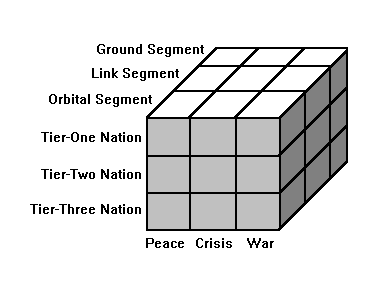
Figure 1: Offensive Counterspace Options
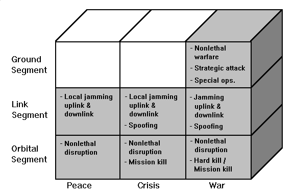
Figure 2: Offensive Counterspace Options for Tier-One Nations
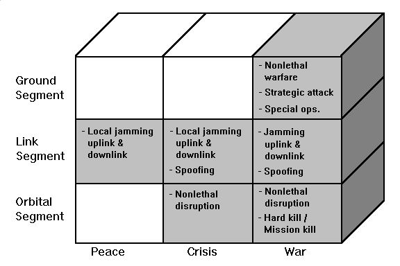
Figure 3: Offensive Counterspace Options for Tier-Two Nations
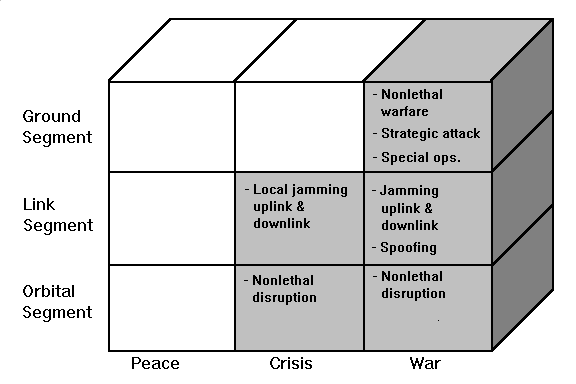
Figure 4: Offensive Counterspace Options for Tier-Three Nations
Second, as the threat from space decreases across the tier groups from tier-one to tier-three, the conflict threshold for attacking space systems segments increases while the level of acceptable violence of the attack decreases. This is illustrated by comparing the available options for attacking the orbital segment during war on both figure 2 and 4. In no case is attacking an orbital segment of a tier-three nation with hard and soft-kill mechanisms viewed as being politically acceptable, whereas it would be against a tier-one nation.
The ability to delay and/or deny information from space systems, at all levels of conflict, permits the establishment of information dominance during peacetime and its sustainment through crisis and war. Determining options for offensive counterspace operations for information dominance can be illustrated in the following scenario. The potential for a crisis exists between the US and a tier-three space nation with a licensed SPOT ground station. If a crisis erupts, the US wants to be prepared with a rapid show of force in the theater of operations and has, therefore, issued an warning order to preposition forces. To insure secrecy, the theater commander has requested offensive counterspace operations be conducted to deny the enemy nation information from the SPOT system that could reveal the force mobilization. As shown in figure 4, the only available option for offensive counterspace operations during peacetime is electronic warfare against the link segment. If the situation escalated to a crisis, or to war, the options for counterspace operations would expand and eventually span all segments of the space and cut across the spectrum of violence from nonlethal to lethal soft-kill, to lethal hard-kill.
Summary
Information dominance strategy as an alternative to the current space control strategy has several advantages. First, because the strategy focuses on the denial of information rather than the denial of the environment, the link and ground segments of the space system correctly reÄemerge with an increased relevance to offensive counterspace operations. This total systems approach has essentially increased operational flexibility of offensive counterspace operations by increasing the operational centers of gravity which can be targeted. Second, the total systems approach, coupled with a philosophy that satellite destruction is no longer essential, has resulted in an increase of available technologies for offensive counterspace operations. Options for employing existing capabilities such as non-lethal directed energy, ECM, and precision guided munitions seem more politically viable than the destructive ASAT, which in the past has been questioned by many within Congress. Finally, the increased number of space system targets subject to attack, coupled with the ability to employ a broader assortment of lethal, and nonlethal technologies, creates options for employing offensive counterspace operations across the spectrum of conflict.
OFFENSIVE COUNTERSPACE OPERATIONS IN SUPPORT OF THE THEATER CAMPAIGN
Traditionally, offensive counterspace operations have been synonymous with an antisatellite (ASAT) capability, employed to deny the medium of space through the destruction of the enemy's orbiting satellites. However, the US does not currently have a capability to destroy satellites on orbit, and judging from the political opposition to such weapons, is not likely to get one. Indeed, even if the US had an operational ASAT capability, situations exist in which the attack and physical destruction of an adversary's satellite is not politically desirable. If the US is to deny the enemy critical warfighting information from satellites, we must adopt an offensive counterspace strategy capable of defeating the enemy's space order of battle within existing political constraints.
Conducting offensive counterspace operations with an objective of attaining information dominance does, however, offer an alternative strategy for controlling space information to the operationally limited strategy of space supremacy. Offensive counterspace operations under an information dominance strategy center on delaying and denying the information and support space systems provide by disrupting or destroying, as required, targets within the orbital, link, and ground segments of the enemy's space system. Consequently, a total systems approach to targeting, encompassing the link and ground segments, in addition to the orbital segment, is employed.
Implementing an offensive counterspace strategy based on information dominance in support of a theater campaign requires the resolution of two major issues: organizational responsibility for implementing an information dominance strategy and the need for a comprehensive space order of battle for the emerging threat from space.
The first issue to be resolved is that of organizational responsibilities, or more specifically, who is responsible for developing and implementing the offensive counterspace strategy.
The Unified Command Plan assigns the responsibility of the space control mission to the Commander-in-Chief United States Space Command (USCINCSPACE); however, the issue of who is responsible for developing and implementing the strategy for offensive counterspace operations in support of a theater campaign would seem to be driven by the responsibilities of the supported commander vis a vis the supporting commander. According to Joint Pub 5-02.1, Joint Operations Planning System (JOPS) Vol I, the supported commander is responsible for coordinating and synchronizing warfighting activities of the supporting commander's military forces in conjunction with his own forces. In addition, the supported commander normally has the authority to designate the objectives and the timing and duration of the supporting commander's actions within the theater. The supporting commander, on the other hand, is responsible for determining the needs of the supported force and taking actions to fulfill them by providing forces and/or developing a plan for supporting the supported commander. Although the supported commander has the authority to determine objectives for the supporting commander, assigning the plan development function to the supporting commander would suggest the responsibility for strategy development and implementation also rests with the supporting commander. According to Joint Pub 0-2, Unified Action Armed Forces, the supporting force gives support or operates in support of another force -- the supported force. Because of their warfighting role in theater campaigns, space forces are normally designated supporting forces. Consequently, USCINCSPACE, as the supporting commander, would be responsible for developing the theater plan for counterspace operations in support of the supported CINC's objectives.
Although USCINCSPACE is responsible for implementing offensive counterspace strategy within the theater, there remains no one within the theater specifically identified for integrating counterspace operations into the theater campaign plan. The emergence of spacepower as a potentially decisive warfighting capability in the aftermath of Desert Storm provides some incentive to identify an individual or organization responsible for integrating counterspace operations into the theater campaign plan.
One alternative would be to create a Joint Forces Space Component Commander (JFSCC) responsible to the Joint Force Commander (JFC). Since Congress chose not to assign the space warfare mission to any single service, but rather to the unified command US Space Command (USSPACECOM), the organizational relationship of the JFSCC to the other services and the unified command for space is not clear. Realistically the JFSCC should be some sort of USSPACECOM element reporting directly to the JFC, and conceptually be similar to a subunified command. One major problem with the JFSCC concept, however, is that as a component command, the forces assigned to the JFSCC would normally be under the operational command of the JFC. However, the operational command of USSPACECOM space forces will not chop to the JFC. Therefore, the JFSCC would essentially be a facilitator or coordinator with USSPACECOM for the surveillance, reconnaissance, communications and weather support requirements of the theater component forces. Although facilitating and coordinating the space requirements into the theater campaign is an important function, creating a new component command, led presumably, by a general officer, to perform coordination activities that could be performed by existing staff elements, seems to be a misappropriation of resources.
With respect to counterspace operations, the JFSCC would coordinate between USCINCSPACE and the JFC and component commanders to insure the space control strategy is consistent with the overall theater strategy and the counterspace operations are integrated into the theater campaign plan. In this capacity the JFSCC would have a role similar to that of the US Transportation Command liaison, who, also has no forces assigned.
Another, and perhaps more defendable, alternative for offensive counterspace operations in support of a theater campaign would be to establish a space planning and operations cell under the JFACC. One potential organization capable of assuming the planning function of offensive counterspace operations for information dominance would be Air Force Space Command's (AFSPACECOM) Forward Space Support in Theater (FSST) team.
The objective of the FSST team is to provide regional CINCs space expertise to facilitate the near-term theater level integration of air and space. FSST teams are currently assigned to Air Force component commands to assist in developing operations plans (OPLANs), training, and insuring integrated space support. While the primary focus of the FSST teams currently centers around the force enhancing attributes of space forces, adding counterspace operations responsibilities appears feasible. Given the propensity for offensive counterspace operations to be conducted by air and electronic warfare forces, subordinating the space planning and operations cell to the JFACC would appear to facilitate the integration of the enemy space order of battle into the overall air operations planning effort and the resulting air tasking order (ATO).
The second issue to resolve for offensive counterspace operations in support of the theater campaign is the requirement for a comprehensive space order of battle for potential enemies. The space order of battle required to support offensive counterspace operations for information dominance must have the same total systems approach as the targeting philosophy. The enemy's order of battle for the orbital segment of a space system includes information such as ephemeris, subsystem vulnerabilities, maneuverability, sensor configuration, and periods of natural disruption such as solar interference, satellite eclipse, and proximity operations. Ground segment order of battle information would include information such as the locations of ground stations and control facilities, the existence of mobile ground stations, and ground station vulnerabilities (such as electrical power). Likewise, order of battle information on the link segment would include information on the number of up/downlinks, frequencies, and anti-jam/encryption capabilities. In addition to the information relating to the physical attributes of a space system, space order of battle should also include operational information such as how the system is used, an assessment of its potential contribution to the enemy's overall military strategy, system reconstitution capabilities, and periods of critical commanding. The existence of a comprehensive space order of battle will facilitate the integration of offensive counterspace operations into the theater operations plan and inclusion of space order of battle targets into the ATO and electronic warfare plan.
Integral to USCINCSPACE's responsibility for planning counterspace operations within the theater is the task of developing and maintaining the space order of battle for the threats from space. Currently, USSPACECOM's Space Defense Operations Center (SPADOC) is responsible for developing and maintaining the space order of battle with data provided from the Joint Space Intelligence Center and the Space Surveillance Center. Because of the Cold War legacy imprinted on our space control strategy, space order of battle is oriented on the Soviet space threat and focuses primarily on the orbiting satellites and includes information such as the satellite function, configuration, orbital parameters, and overflight predictions. However, since an information dominance strategy focuses on attacking the entire space system, the level of effort needed to develop and maintain a space order of battle for counterspace operations appears to exceed the current capabilities of the SPADOC.
As space technology proliferates, the need for a US strategy to exercise control over potentially threatening space systems increases. Basing our offensive counterspace operations on a strategy of information dominance seems to be a logical approach for determining the focus of a space control campaign. Even though the US has no dedicated operational ASAT capability to provide the lethal, hard-kill options, there are many operational weapon systems that possess inherent capabilities for lethal soft-kill, or non-lethal counterspace applications.
It is increasingly clear that space capabilities are becoming more decisive in the outcome of war. In the current political environment, we need to be more creative and innovative in our approaches to solving national security problems. Information dominance represents a different approach for confronting the threat from multilateral space capabilities and for viewing the objectives of our space control mission.
This work was accomplished in partial fulfillment of the Masters Degree requirements of the School of Advanced Airpower Studies, Air University, Maxwell AFB, AL, 1996.
Advisor: Col James K. Feldman, Ph.D.
Reader: Lt Col Gary P. Cox, Ph.D.