
Table of
Contents
|
Table of Contents |
At the strategic level (intelligence) was fine. But we did not get enough tactical intelligence--front line battle intelligence.
|
|
--General Merrill A. McPeak |
GSMs operate differently, depending upon echelon and unit they support. Understanding the system and tasking becomes even more critical. For example, an artillery brigade's GSM operates differently than a Corps Tactical Operations Center (CTOCs) GSM. Team work between GSMs is also essential on the battlefield. One brigade's GSM may have to cover another brigade's sector if its GSM is down for maintenance or is performing operations on the move.
A GSM in a force projection brigade and another GSM supporting a corps DISE may have to split the coverage area so that the operators are not overwhelmed with collection tasking. Splitting the coverage area would be done until other units arrive in theater with their GSMs. GSM operators will also have to be flexible to changing mission profiles. GSMs can be quickly shifted if other GSMs are destroyed by enemy fire or encounter maintenance problems.
ECHELONS ABOVE CORPS (THEATER ARMY) |
The commander's mission needs dictate the placement of the two GSMs at this echelon. The mission could be in support of the JIC, the Theater ACE, the DISE, or the AOC or BCE. Its prime missions are--
CORPS AND DIVISION GSM PRODUCTS AND APPLICATIONS |
With a corps size area of interest and operations, the GSM operator can quickly become overtasked if the system is expected to collect against a multitude of point NAIs throughout this area. When collecting against NAIs, operators zoom into this area, 1:50,000 scale or less (about 14 km square area), and lose sight of area situational developments.
At corps and division, area control boxes that overlay NAIs are used instead of the NAIs. This prevents the operator from limiting Joint STARS capability by zooming in on a small area. As an example, a 50 km control box could be used for MSRs; this would give the command the same information as four or five NAIs, and the operator would never lose sight of the coverage area. A corps or division should use only 4 to 8 high-value NAIs during an 8-hour mission. Figure 4-1 shows usage of an area control box. Divisions and force projection brigades with large fronts and deep AIs should also use this concept so that the GSM operator is not overtasked. Joint STARS reports include--

Joint STARS GSMs area critical link in C3I at brigade and ACR levels. A brigade or ACR's concerns are enemy operations that will impact friendly operations within 12 to 24 hours.
Commanders can now make key decisions in maneuver, targeting, and offensive and defensive operations because of the unique Joint STARS ability of viewing the evolving battlefield.
Collection managers and S2s must provide Joint STARS operators operations and collection graphics in order for the operators to provide the commander a complete situational overview. Figure 4-2 shows Joint STARS imagery with operational and intelligence graphics.

Joint STARS can be used in support of most division and corps aviation operations. Three main areas where Joint STARS can be of high value are in support of interdiction (attack) missions, insertion operations, and aeroscout missions.
Besides intelligence collection, Joint STARS can provide targeting, preplanned interdiction missions, and target updating to the attack force, via secure FM, during the operation.
The ability to locate enemy air defense systems through the JTT is extremely valuable during mission planning and while operations are underway. This information is displayed on the operator's screen and on a hardcopy color print, with imagery graphics and JTT data. It can be used to update the command's air event template. Figure 4-3 shows Joint STARS targeting in support of aviation operations (with JTT information).

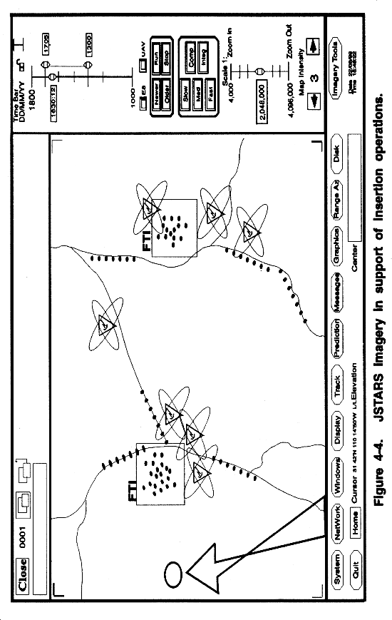
Joint STARS is also an excellent tool for insertion operations. The GSM's viewing screens can zoom into any given area within the Joint STARS aircraft's radar footprint. Operators can provide analysis of the area locating moving or fixed targets as well as information on active ADA associated radars. The operators can provide a hardcopy color print overlaid on digital terrain data or E-maps. Figure 4-4 shows Joint STARS imagery in support of insertion operations. GSM operators can provide updated information directly to the helicopter if the status of the area has changed while the mission is underway.
Joint STARS GSMs cue aeroscout operations by the aviation brigade, ACR, or through direct contact to the air asset via secure FM. The GSM operators will need the operational graphics air event template to plot in their database.
The main support to division and corps artillery is in the form of targeting. Joint STARS can locate, track, identify wheeled and tracked vehicles, and predict arrival times and coordinates of moving targets. The system can bracket areas and give the commander a count of fixed targets within that area. This targeting information can be autofilled in preformatted TACFIRE or ASAS messages and can be sent electronically, hardwire, or digital FM to the commander. Figure 4-5 is an example of Joint STARS support to the targeting process.

No other intelligence collection systems complement one another more than Joint STARS and UAV. Each system's strength supports the other's weakness. UAV's ability is extremely limited when used for general search and detection over unfamiliar terrain. UAV is effective when used to observe point targets or conduct route reconnaissance. Joint STARS with area coverage can locate targets to direct UAV to investigate. This gives the command increased ability to analyze the battlefield. By combining both, the command can receive a single product--fused imagery and information. Figure 4-6 shows Joint STARS imagery and UAV imagery fused into a single product.

Examples of Joint STARS-UAV cueing modes --OBSERVATION-CUE-OBSERVATION--are discussed below.
In some scenarios the collection manager, G2/S2, or the commander may want simultaneous collection of certain targets. This may be useful in directing targeting operations, intelligence collection, BDA, or even in operations other than war (OOTW) (for example, identification of drug processing facilities, guerrilla camps, massing of arms, or treaty verification).
The GSM currently receives UAV imagery and telemetry data via two wire cables between the GCS-UAV and the GSM. To display UAV imagery, the GSM operator creates a UAV video window in the operator display. Joint GSM operator creates a UAV video window in the operator display. Joint STARS imagery, UAV imagery, and SIGINT data icons can all run or be displayed simultaneously.
Joint STARS imagery and UAV imagery are recorded in two separate recording devices within the GSM. This provides an excellent database of imagery for post-analysis and change-detection analysis. Cueing operations must be directed and approved by the S2 or collection manager. In certain situations the S2 or collection manager may authorize direct cueing coordination between UAV and GSM operators. The operators of the two systems can communicate via MSE, AN/VRC-92, or AN/TA-312.
With the changing world--post cold war--military forces are called upon more often for OOTW. OOTW may be combative or noncombative in nature. These operations are numerous with possibly no two exactly the same. Joint STARS, with its standoff WAS capability, is ideal to support a large number of these missions. This standoff capability provides intelligence collection in support of national interest without violation of another nation's airspace. Joint STARS is well suited to support the missions listed below.
Drug Interdiction. Joint STARS can locate drug processing facilities, camps, and agricultural areas. The system can confirm or deny activity at these sites (SAR and Spotlight modes); trafficking routes to observe for activity on airfields, roads, waterways, or cross-country (MTI, FTI, and Spotlight modes); vectoring in air mobile and ground operations or supporting host nation (HN) interdiction operations (MTI or Spotlight modes).
Guerrilla Activity. This involves locating operation centers and encampments (SAR and FTI), as well as tracking of "some" insurgency activity (Spotlight modes).
HN Security Operations. This involves detecting buildup of heavy arms by bordering nations or internal factions (all modes). It also involves cuing and directing counterinsurgency operations based on imagery (all modes).
Monitoring Treaties and International Agreements. This involves observing arms movement, buildup, and positioning of forces (all modes). It also involves observing possession of illegal weapons (SAR, JTT, and cross-cueing).
Peacekeeping and Humanitarian Aid. This involves locating hostile activity and the direction of humanitarian aid based on the hostile action or its potential (MTI and Spotlight modes). It also involves monitoring friendly aid convoys in a potentially hostile environment for success (MTI and

FUTURE CAPABILITIES |
The next generation system scheduled to replace the GSM is the CGS. Similar in appearance and function to the LGSM, the CGS is a leap forward in technology and function. This system increases the commander's ability to assess the battlefield situation; it also increases the speed of accessing intelligence not normally found at a brigade level command. The following features will be improved in the CGS.
The JTT system will be upgraded from a two-channel, receive-only hybrid system to the three-channel, receive-only system. This will allow access to the Secondary Imagery Dissemination System (SIDS) via the general purpose link (GPL). The CGS operator will be able to open a window on the operator's display and call up digitally stored imagery from corps or EAC databases. The digital imagery would already be annotated and thoroughly analyzed. (See Appendix D.)
The CGS will have its own antenna to intercept the downlink from UAV. This antenna will eliminate the currently required hardware interface with the GCS-UAV.
The third capability is the interface with aviation assets (for example, A2C2S, Kiowa-Warrior, Apache-Longbow, and Comanche). There are two modes being tested for interface: data message and secondary imagery.
Data Message Interface. The data message interface will be similar to the LGSM's ASAS and TACFIRE interface via IDM. The attack or scout helicopters possess the capability of electro-optical and infrared imaging. A datalink could be established so the aviation commander can see the battlefield through his assets and use this information in either the intelligence collection or operations control mode. Some air assets may also receive uplink capability so that the commander may have visual battlefield information in the A2C2S helicopter.
Secondary Imagery Interface. Secondary imagery, Joint STARS imagery, UAV imagery, and JTT SIGINT data used simultaneously are examples of change detection of an area. Figure 4-8 shows multiple sensor imagery with JTT SIGINT data in change detection operations. Other uses of secondary imagery include obstacle and fortification detection and in-depth analysis of an area and targeting operations.
